Meteorologist Ray Stagich
WLS-AM
Tuesday, February 7, 2017 Close to record warmth on Monday. Mild, early Spring-like warmth into Tuesday. Some dense fog will be around with all the added warmth. A quick dive back into winter cold WED-THU. Another warm up for the end of the work week…..Some storms possible towards sunrise. Snow showers or some flurries later in the week as the cold returns…..
Monday at O’Hare:
High: 55
Low: 21
THE CHICAGO-OHARE CLIMATE NORMALS FOR TODAY
NORMAL RECORD YEAR
MAXIMUM TEMPERATURE (F) 33 59 1925
MINIMUM TEMPERATURE (F) 18 -10 1875
SUNRISE AND SUNSET
FEBRUARY 7 2017……SUNRISE 657 AM CST SUNSET 515 PM CST
FEBRUARY 8 2017……SUNRISE 656 AM CST SUNSET 516 PM CST
**Dense Fog Advisory until Noon CST on Tuesday**
Today | FOG this morning with scattered showers and Thunderstorms. Cloudy skies this afternoon. High near 50F. S winds shifting to W at 15 to 25 mph. Chance of rain 90%.
Tonight | Cloudy. Gusty winds this evening. Low near 25F. Winds NW at 20 to 30 mph.
Tomorrow | Cloudy skies early, then partly cloudy in the afternoon. A few flurries or snow showers possible. High around 30F. Winds NNW at 10 to 15 mph.
Tomorrow night | Partly cloudy skies. Low 12F. Winds NW at 15 to 25 mph.
Thursday | Abundant sunshine. Highs in the mid-20s and lows in the mid teens.
Friday | Times of sun and clouds. Highs in the mid-40s and lows in the mid-30s.
Saturday | Afternoon showers. Highs in the upper 40s and lows in the upper 30s.
Sunday | Showers ending by midday. Highs in the low 40s and lows in the upper 20s.
Monday | Sunshine. Highs in the low 40s and lows in the upper 20s.
Meteorologist Ray Stagich
WLS-AM Forecast
Wednesday, Nov. 2
WARMTH FOR EARLY NOVEMBER CONTINUES.
SOUTHWEST FLOW BRINGING MILD, WET WEATHER SYSTEMS INTO OUR MIDWEEK FORECAST.
A LITTLE COOLER LATE WEEK. NOTHING TOO COLD AT ALL FOR EARLY NOVEMBER.
GAME 7 Forecast: Mainly cloudy, temps near 70 at first pitch with light winds.
SUNRISE AND SUNSET
NOVEMBER 2 2016 – SUNRISE 726 AM CDT SUNSET 544 PM CDT
NOVEMBER 3 2016 – SUNRISE 727 AM CDT SUNSET 543 PM CDT
Today | Isolated thunderstorms (more to the west and north) during the morning becoming more widespread this afternoon. High around 70F. Winds SSE at 5 to 10 mph. Chance of rain 80%.
Tonight | Thunderstorms during the evening will give way to partly cloudy skies after midnight. Low 47F. Winds N at 10 to 15 mph. Chance of rain 80%.
Tomorrow | Partly cloudy skies. High 64F. Winds NNW at 5 to 10 mph.
Tomorrow night | Clear skies. Low 43F. Winds NNE at 5 to 10 mph.
Friday | Sunshine. Highs in the low 60s and lows in the mid-40s.
Saturday | Mainly sunny. Highs in the mid-60s and lows in the low 40s.
Sunday | Sunny. Highs in the mid-60s and lows in the mid-40s.
Meteorolgist Ray Stagich
WLS-AM Forecast
Wednesday, September 21, 2016
SUNRISE AND SUNSET
SEPTEMBER 21 2016 – SUNRISE 638 AM CDT SUNSET 650 PM CDT
SEPTEMBER 22 2016 – SUNRISE 639 AM CDT SUNSET 648 PM CDT
Today| Mainly cloudy. A stray shower or thunderstorm is possible. (Better chance of rain north, especially this morning…) High 84F. Winds SSW at 10 to 15 mph.
Tonight | Scattered thunderstorms early, then mainly cloudy after midnight. Low near 65F. Winds SSE at 5 to 10 mph. Chance of rain 40%.
Tomorrow | A mix of clouds and sun in the morning followed by cloudy skies during the afternoon. A stray shower or thunderstorm is possible. High 86F. Winds SSW at 10 to 15 mph.
Tomorrow night | Cloudy. A stray shower or thunderstorm is possible. Low 66F. Winds NE at 5 to 10 mph.
Friday | Cloudy. Highs in the upper 70s and lows in the mid 60s.
Saturday | Times of sun and clouds. Highs in the upper 70s and lows in the low 60s.
Sunday | Afternoon thunderstorms. Highs in the upper 70s and lows in the low 60s.
Monday | Isolated thunderstorms. Highs in the upper 70s and lows in the low 60s.
Tuesday | Showers. Highs in the low 70s and lows in the low 60s.
Meteorologist Ray Stagich WLS-AM Monday, September 19th, 2016
WARMER THAN AVERAGE TEMPERATURES EXPECTED TO CONTINUE THIS WEEK. A QUICK-MOVING COLD FRONT WILL SPARK WIDELY SCATTERED SHOWERS AND STORMS LATE MONDAY AFTERNOON THROUGH PARTS OF THE OVERNIGHT HOURS. THERE IS A SLIGHT CHANCE FOR A STRAY SEVERE STORM MONDAY EVENING.
SUNRISE AND SUNSET
SEPTEMBER 19 2016 – SUNRISE 636 AM CDT SUNSET 653 PM CDT
SEPTEMBER 20 2016 – SUNRISE 637 AM CDT SUNSET 651 PM CDT
Today | Sunshine and a few afternoon clouds. A stray shower or thunderstorm is possible. High around 85F. Winds SW at 10 to 20 mph.
Tonight | Variable clouds with scattered thunderstorms. Low 64F. Winds W at 5 to 10 mph. Chance of rain 60%.
Tomorrow | Mainly sunny. High 81F. (cooler lake) Winds ENE at 5 to 10 mph.
Tomorrow night | A mostly clear sky. Low 62F. Winds ESE at 5 to 10 mph.
Wednesday | Partly cloudy. Highs in the mid-80s and lows in the upper 60s.
Thursday | Mix of sun and clouds. Highs in the mid-80s and lows in the upper 60s.
Friday | Mix of sun and clouds. Highs in the low 80s and lows in the upper 60s.
Saturday | Partly cloudy. Highs in the upper 70s and lows in the low 60s.
Sunday | Clouds giving way to sunshine . Highs in the mid-70s and lows in the upper 50s.
Meteorologist Ray Stagich WLS-AM Monday, August 22, 2016
HIGH PRESSURE WILL LEAD TO A BEAUTIFUL START TO THE WORK WEEK. EXPECT PLENTY OF SUNSHINE MONDAY WITH COMFORTABLE CONDITIONS.
SOUTHERLY FLOW WILL INCREASE THE LOW-LEVEL MOISTURE TUESDAY BRINGING SLIGHTLY WARMER AIR TO THE REGION. SHOWER AND STORM CHANCES RETURN WEDNESDAY.
SUNRISE AND SUNSET
AUGUST 22 2016 – SUNRISE 607 AM CDT SUNSET 741 PM CDT
AUGUST 23 2016 – SUNRISE 608 AM CDT SUNSET 739 PM CDT
Today | Sunny. High around 80F. Winds SW at 10 to 15 mph.
Tonight | Clear skies. Low 61F. Winds S at 10 to 15 mph.
Tomorrow | Generally sunny despite a few afternoon clouds. High 83F. Winds S at 10 to 20 mph.
Tomorrow night | Partial cloudiness early, with scattered showers and thunderstorms later during the night. Low 67F. Winds S at 10 to 15 mph. Chance of rain 50%.
Wednesday | A few thunderstorms possible. Highs in the low 80s and lows in the low 70s.
Thursday | Morning clouds followed by afternoon sun. Highs in the low 80s and lows in the low 60s.
Friday | Partly cloudy. Highs in the upper 70s and lows in the low 60s.
Saturday | Partly cloudy. Highs in the upper 70s and lows in the mid 60s.
Sunday | Times of sun and clouds. Highs in the low 80s and lows in the mid 60s.
Meteorologist Ray Stagich WLS-AM Thursday, August 11, 2016
Hot & humid into Thursday afternoon. An approaching front may trigger strong storms on Friday.
SUNRISE AND SUNSET
AUGUST 11 2016 – SUNRISE 556 AM CDT SUNSET 757 PM CDT
AUGUST 12 2016 – SUNRISE 557 AM CDT SUNSET 755 PM CDT
Today | Sun and clouds mixed. High 92F. Heat Index mid to upper 90s…..Winds SSW at 10 to 15 mph.
Tonight | Scattered clouds with the possibility of an isolated thunderstorm developing late. Low around 75F. Winds SSW at 10 to 15 mph. Chance of rain 30%.
Tomorrow | Thunderstorms. A few storms may be severe. High around 85F. Winds SW at 10 to 15 mph. Chance of rain 90%.
Tomorrow night | Thunderstorms during the evening, then cloudy skies overnight. Low 71F. Winds WNW at 5 to 10 mph. Chance of rain 80%.
Saturday | Partly cloudy. Highs in the mid 80s and lows in the upper 60s.
Sunday | Times of sun and clouds. Highs in the mid 80s and lows in the mid 60s.
Monday | Partly cloudy. Highs in the low 80s and lows in the mid 60s.
Tuesday | Showers possible. Highs in the low 80s and lows in the mid 60s.
Wednesday | Mainly sunny. Highs in the mid 80s and lows in the mid 60s.
Forecast Summary Meteorologist Ray Stagich WLS-AM Forecast Wednesday, July 13, 2016
Rain & storm chances increasing Wednesday afternoon and evening ahead of a plains cold front. Some storms could be on the strong side. Quieter weather Thursday through Saturday. More storms possible Sunday.Staying on the warm and humid side through late Wednesday. Somewhat more comfortable air arriving for the end of the work week and to start the weekend.
Strong winds and hail with heavy rain will be most likely early tonight.
SUNRISE AND SUNSET
JULY 13 2016 – SUNRISE 528 AM CDT SUNSET 826 PM CDT
JULY 14 2016 – SUNRISE 529 AM CDT SUNSET 826 PM CDT
Today | Partly to mostly cloudy with a chance of thunderstorms. A few storms may be severe. High 88F. Winds SW at 10 to 20 mph. Chance of rain 50%.
Tonight | Scattered thunderstorms during the evening. Partly cloudy skies after midnight. A few storms may be severe. Low near 70F. Winds WSW at 10 to 15 mph. Chance of rain 50%.
Tomorrow | Some clouds in the morning will give way to mainly sunny skies for the afternoon. High 89F. Winds W at 10 to 20 mph.
Tomorrow night | Clear skies. Low near 65F. Winds WNW at 10 to 20 mph.
Friday | More clouds than sun. Highs in the upper 70s and lows in the low 60s.
Saturday | Mix of sun and clouds. Highs in the low 80s and lows in the mid 60s.
Sunday | Thunderstorms developing in the afternoon. Highs in the mid 80s and lows in the upper 60s
.
Monday | Scattered thunderstorms. Highs in the upper 80s and lows in the upper 60s.
Tuesday | Partly cloudy. Highs in the low 90s and lows in the low 70s.
Meteorologist Ray Stagich WLS-AM Monday, July 11th, 2016 Hotter weather now in for a few days with SEVERE STORMS POSSIBLE TUESDAY AS A PAIR OF FRONTS PUSH THROUGH THE REGION.
SUNRISE AND SUNSET
JULY 11 2016 – SUNRISE 527 AM CDT SUNSET 827 PM CDT
JULY 12 2016 – SUNRISE 527 AM CDT SUNSET 827 PM CDT
Today | Considerable cloudiness. A stray shower or thunderstorm is possible. High 92F. Winds S at 10 to 20 mph.
Tonight | Clear to partly cloudy. A stray shower or thunderstorm is possible. Low 73F. Winds S at 10 to 20 mph.
Tomorrow | Partly cloudy skies in the morning will give way to cloudy skies during the afternoon. A stray severe thunderstorm is possible. High 92F. Winds SSW at 10 to 20 mph.
Tomorrow night | Thunderstorms likely in the evening. Then the chance of scattered thunderstorms later on. A few storms may be severe. Low 73F. Winds SSW at 10 to 15 mph. Chance of rain 80%.
Wednesday | Scattered thunderstorms possible. Highs in the low 90s and lows in the low 70s.
Thursday | Partly cloudy. Highs in the upper 80s and lows in the mid 60s.
Friday | Showers and thunderstorms late. Highs in the upper 70s and lows in the low 60s.
Saturday | More sun than clouds. Highs in the low 80s and lows in the upper 60s.
Sunday | Mix of sun and clouds. Highs in the upper 80s and lows in the low 70s.
Meteorologist Ray Stagich
WLS-AM
Wednesday, June 22, 2016 Heavy rain in spots first this morning. Most of it west and south. SEVERE weather with Tornadoes late today and tonight.
SUNRISE AND SUNSET
JUNE 22 2016 – SUNRISE 517 AM CDT SUNSET 831 PM CDT
JUNE 23 2016 – SUNRISE 517 AM CDT SUNSET 831 PM CDT
FFWATCH 10AM WEDNESDAY – RAINFALL RATES UP TO 1″-2″ PER HOUR POSSIBLE
Today | Variable clouds with thunderstorms – possibly severe this afternoon. Damaging winds and large hail with some storms. High 78F. SSW winds shifting to ESE at 10 to 15 mph. Chance of rain 90%.
Tonight | Thunderstorms, some strong early, then cloudy skies after midnight. Damaging winds and large hail with some storms. Low 64F. Winds NE at 10 to 15 mph. Chance of rain 80%.
Tomorrow | Cloudy skies early, followed by partial clearing. Slight chance of a rain shower. High near 75F. Winds NNE at 10 to 15 mph.
Tomorrow night | Clear skies. Low 58F. Winds NNE at 10 to 15 mph.
Friday | Sunny. Highs in the low 80s and lows in the mid 60s.
Saturday | Abundant sunshine. Highs in the low 90s and lows in the low 70s.
Sunday | Thunderstorms. Highs in the low 90s and lows in the upper 60s.
Monday | Sunny. Highs in the low 90s and lows in the mid 60s.
Tuesday | Times of sun and clouds. Highs in the mid 70s and lows in the upper 50s.
Meteorologist Ray Stagich WLS-AM Forecast Wednesday, May 25, 2016
**Heat and humidity stays around(July-like heat) and storm chances up the rest of the work week. Highest rain chances Wed. Night into Thu. A few strong/severe storms could occur during that time as well. more of a summertime-muggy splash and dash t-storm set up for Memorial Day Weekend*
SUNRISE AND SUNSET
MAY 25 2016 – SUNRISE 522 AM CDT SUNSET 815 PM CDT
MAY 26 2016 – SUNRISE 522 AM CDT SUNSET 816 PM CDT Today | Partial cloudiness early, with scattered showers and thunderstorms during the afternoon. High near 85F. Winds S at 10 to 20 mph. Chance of rain 40%.
Tonight | Scattered showers and thunderstorms. Low 67F. Winds S at 10 to 15 mph. Chance of rain 60%.
Tomorrow | Cloudy early with partial sunshine expected late. A stray shower or thunderstorm is possible. High 88F. Winds SSW at 10 to 20 mph.
Tomorrow night | Scattered thunderstorms in the evening. Cloudy skies overnight. Low 68F. Winds SSW at 5 to 10 mph. Chance of rain 60%.
Friday | Thunderstorms. Highs in the low 80s and lows in the upper 60s.
Saturday | Afternoon showers and thunderstorms. Highs in the low 80s and lows in the mid 60s.
Sunday | Thunderstorms early. Highs in the mid 80s and lows in the mid 60s.
Monday | Times of sun and clouds. Highs in the mid 80s and lows in the mid 60s.
Tuesday | A few clouds. Highs in the low 80s and lows in the low 60s.
Meteorologist Ray Stagich WLS-AM Forecast Monday, May 9th, 2016
An active weather pattern will bring periods of showers and storms through Thursday with the best chances for precipitation late Monday into early Wednesday morning.
SUNRISE AND SUNSET
MAY 9 2016 – SUNRISE 537 AM CDT SUNSET 800 PM CDT
MAY 10 2016 – SUNRISE 536 AM CDT SUNSET 801 PM CDT
Today | Breezy…Overcast with rain showers….steadier south this morning….High 56F. Winds ESE at 15 to 25 mph. Chance of rain 50%.
Tonight | Rain. Low 51F. Winds ESE at 10 to 20 mph. Chance of rain 90%. Rainfall near a half an inch.
Tomorrow | Rain early with thunderstorms developing in the afternoon. High 67F. Winds ESE at 10 to 20 mph. Chance of rain 80%.
Tomorrow night | Cloudy with showers. Thunder possible. Low 56F. Winds E at 5 to 10 mph. Chance of rain 50%.
Wednesday | Areas of morning fog, then some sun. Highs in the low 70s and lows in the upper 50s.
Thursday | Windy with morning clouds, then afternoon sun. Highs in the low 70s and lows in the low 50s.
Friday | Mostly sunny. Highs in the mid 60s and lows in the mid 40s.
Saturday | Times of sun and clouds. Highs in the mid 50s and lows in the low 40s.
Sunday | Mix of sun and clouds. Highs in the low 60s and lows in the mid 40s.
Meteorologist Ray Stagich WLS Weather Forecast Monday, July13th, 2015
FLASH FLOOD WATCH IS IN EFFECT FROM 1AM MONDAY THROUGH LATE MONDAY NIGHT.
SEVERE THUNDERSTORM WATCH OUTLINE UPDATE FOR WS 408
NWS STORM PREDICTION CENTER NORMAN OK
410 AM CDT MON JUL 13 2015
SEVERE THUNDERSTORM WATCH 408 IS IN EFFECT UNTIL 1000 AM CDT FOR THE FOLLOWING LOCATIONS IL. ILLINOIS COUNTIES INCLUDED ARE:
BOONE BUREAU CARROLL
COOK DE KALB DUPAGE
GRUNDY JO DAVIESS KANE
KENDALL LAKE LA SALLE
LEE MCHENRY OGLE
PUTNAM STEPHENSON WHITESIDE
WILL WINNEBAGO
2 ROUNDS OF POTENTIALLY SEVERE STORMS. THE FIRST INTO PARTS OF MONDAY MORNING; THE SECOND ROUND MONDAY AFTERNOON/EVENING.
LARGE HAIL, DAMAGING WINDS, FLASH FLOODING POSSIBLE IN BOTH THESE EVENTS. ISOLATED TORNADOES ALSO POSSIBLE DURING THE PM HOURS MONDAY.
More storms possbile on Tuesday…..
SUNRISE AND SUNSET
JULY 13 2015 – SUNRISE 5:28 AM CDT SUNSET 8:27 PM CDT
JULY 14 2015 – SUNRISE 5:28 AM CDT SUNSET 8:26 PM CDT
Today | Strong thunderstorms likely. Damaging winds and large hail with some storms. Heavy rain coming in two rounds….one in the morning and one this afternoon. High 88F. Winds SSW at 10 to 15 mph. Chance of rain 100%. Rainfall near an inch. With locally higher totals.
Tonight | Partly to mostly cloudy skies with scattered thunderstorms during the evening. A few storms may be severe. Low 69F. Winds WSW at 10 to 15 mph. Chance of rain 60%.
Tomorrow | Scattered thunderstorms in the morning becoming more widespread in the afternoon. High 81F. Winds NNW at 10 to 15 mph. Chance of rain 80%.
Tomorrow night | A few clouds. Low around 60F. Winds NNE at 10 to 15 mph.
Wednesday | A few clouds. Highs in the mid 70s and lows in the upper 50s.
Thursday | Mix of sun and clouds. Highs in the low 80s and lows in the mid 60s.
Friday | Scattered thunderstorms. Highs in the mid 80s and lows in the upper 60s.
Ray’s Note:Temperatures will run closer to average from Friday into the weekend. Scattered showers and thunderstorms return later Saturday into Saturday night and Sunday….
SUNRISE AND SUNSET
JULY 10 2015 – SUNRISE 525 AM CDT SUNSET 828 PM CDT
JULY 11 2015 – SUNRISE 526 AM CDT SUNSET 828 PM CDT
Today | Areas of fog this morning…otherwise…Sunshine and clouds mixed. High around 80F. Cooler by the lake. Winds ENE at 5 to 10 mph.
Tonight | Clear skies. Low near 60F. Winds SSE at 5 to 10 mph.
Tomorrow | A mix of clouds and sun early, then becoming cloudy later in the day. A stray shower or thunderstorm is possible. High 81F. Winds S at 5 to 10 mph.
Tomorrow night | Variable clouds with scattered thunderstorms. Low 68F. Winds SSE at 5 to 10 mph. Chance of rain 50%.
Sunday | A few thunderstorms possible. Highs in the mid 80s and lows in the low 70s.
Monday | Showers and thunderstorms late. Highs in the low 80s and lows in the upper 60s.
Tuesday | Times of sun and clouds. Highs in the low 80s and lows in the mid 60s.
Meteorologist Ray Stagich WLS-AM Tuesday, June 30th, 2015
Ray’s Note: Just hit and miss storms today then some beautiful weather in for the rest of the week!!!
Today | Partly cloudy. isolated shower/thunderstorm is possible. High near 75F. Cooler by the lake. Winds NNW at 10 to 15 mph.
Tonight | Some clouds. Low 56F. Winds NNE at 10 to 15 mph.
Tomorrow | Partly cloudy skies. High 68F.(cooler lake) Winds ENE at 10 to 15 mph.
Tomorrow night | Partly cloudy skies. Low 52F. Winds NNE at 10 to 15 mph.
Thursday | Abundant sunshine. Highs in the low 70s (cooler lake) and lows in the mid 50s.
Friday | Mix of sun and clouds. Highs in the mid 70s and lows in the upper 50s.
Saturday | More sun than clouds. Highs in the upper 70s and lows in the low 60s.
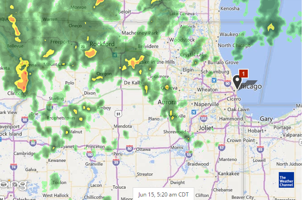
Meteorologist Ray Stagich WLS-AM Monday, June 15th, 2015
RAY’S NOTE: SCATTERED SHOWERS AND THUNDERSTORMS CONTINUE THROUGH MONDAY. THE STRONGEST, OF WHICH, MAY PRODUCE: LOCALIZED FLOODING, FREQUENT CLOUD TO GROUND LIGHTNING AND ISOLATED WIND GUSTS OF 60 MPH.
Photo: Radar from Weather.com
SUNRISE AND SUNSET
JUNE 15 2015 – SUNRISE 515 AM CDT SUNSET 829 PM CDT
JUNE 16 2015 – SUNRISE 516 AM CDT SUNSET 829 PM CDT
Today | Scattered thunderstorms this morning, then mainly cloudy during the afternoon with thunderstorms likely. A few storms may be severe. Heavy rain and gusty winds possbile. High near 80F. Winds SW at 10 to 15 mph. Chance of rain 80%.
Tonight | Thunderstorms early, then cloudy skies after midnight. A few storms may be severe. Low 63F. Winds NW at 10 to 15 mph. Chance of rain 80%.
Tomorrow | Decreasing clouds… High 68F. (cooler lake) Winds NE at 10 to 15 mph.
Tomorrow night | Considerable cloudiness. Low around 55F. Winds NE at 10 to 15 mph.
Wednesday | Scattered thunderstorms. Highs in the upper 70s and lows in the mid 60s.
Thursday | A few thunderstorms possible. Highs in the upper 70s and lows in the upper 50s.
Friday | Afternoon thunderstorms. Highs in the upper 70s and lows in the mid 60s.
Meteorologist Ray Stagich WLS-AM Tuesday, June 9th, 2015
Ray’s Note: Mild weather continues. It might get close to 90 tomorrow, but not quite sure if we will hit it, however. End of the week looks a little stormy.
SUNRISE AND SUNSET
JUNE 9 2015 – SUNRISE 516 AM CDT SUNSET 826 PM CDT
JUNE 10 2015 – SUNRISE 516 AM CDT SUNSET 826 PM CDT
Today | Some clouds early…maybe some fog in spots….then a good deal of sunshine. High near 85F. Cooler by the lake. Winds W at 10 to 15 mph.
Tonight | Clear to partly cloudy. A stray shower or thunderstorm is possible. Low 69F. Winds SW at 10 to 20 mph.
Tomorrow | Generally sunny despite a few afternoon clouds. High 87F. Winds W at 10 to 20 mph.
Tomorrow night | Partly cloudy. Low 61F. Winds NNE at 5 to 10 mph.
Thursday | Showers. Highs in the upper 70s and lows in the low 60s.
Friday | Thunderstorms. Highs in the low 80s and lows in the low 60s.
Saturday | Cloudy. Highs in the low 70s and lows in the low 60s.
Update: A second round of storms may be on the way, capable of locally heavy rainfall, possible flash flooding, damaging wind in excess of 60 MPH and hail the size of quarters. Watch real time weather radar here.
Today | Windy with strong thunderstorms likely. High close to 80
Tonight | Evening storms possible with a chance for heavy rain. Low around 65
Tomorrow | Partial cloudiness early, with scattered showers and thunderstorms in the afternoon. High low to mid 80s
Monday night | Partly cloudy skies. Maybe a stray evening thunderstorm. Low near 60
Tuesday | More sun than clouds. High near 85
Wednesday | Showers and thunderstorms possible. High mid to upper 80s
Thursday | Times of sun and clouds. A stray thunderstorm. High mid 70s to near 80
Meteorologist Ray Stagich
WLS-AM
Friday, May 29th, 2015
Ray’s Note: Somewhat of an active weather pattern returning today and into the start of the weekend. A big cool down for the last weekend of May with FALLING temps during the afternoon and evening on Saturday.
SUNRISE AND SUNSET
MAY 29 2015 – SUNRISE 520 AM CDT SUNSET 818 PM CDT
MAY 30 2015 – SUNRISE 520 AM CDT SUNSET 819 PM CDT Today | Scattered showers and thunderstorms. High 81F. Winds SSW at 10 to 20 mph. Chance of rain 50%.
Tonight | Mostly cloudy with showers and a possible thunderstorm especially late. Low near 65F. Winds SW at 10 to 15 mph. Chance of rain 80%.
Tomorrow | Cloudy with rain ending in the afternoon. Windy at times late. High 66F and falling possibly into the 40s by evening!!!!
Winds NNE at 20 to 30 mph. Chance of rain 70%. Rainfall near a quarter of an inch.
Tomorrow night | Partly cloudy. Windy. Low 43F. Winds NNE at 20 to 30 mph.
Sunday | Times of sun and clouds. Highs in the upper 50s and lows in the mid 40s.
Monday | Times of sun and clouds. Highs in the mid 60s and lows in the low 50s.
Tuesday | Plenty of sun. Highs in the mid 70s and lows in the upper 50s.
Ray’s Note: Scattered thunderstorms developing SW to NE this morning. Some heavy rain and large hail and damaging winds in spots.
SUNRISE AND SUNSET
MAY 11 2015………..SUNRISE 536 AM CDT SUNSET 801 PM CDT
MAY 12 2015………..SUNRISE 535 AM CDT SUNSET 802 PM CDT
Today | Areas of dense morning fog. Variable clouds with showers and scattered thunderstorms. High around 70F. Winds SW at 15 to 25 mph. Windy at times. Chance of rain 70%.
Tonight | A few clouds. Windy Low 47F. Winds WSW at 15 to 25 mph.
Tomorrow | Windy and partly cloudy early. Mostly cloudy with diminishing winds later in the day. High 59F. Winds W at 20 to 30 mph.
Tomorrow night | Partly cloudy skies. Low 41F. Winds NNW at 10 to 20 mph.
Wednesday | Sunshine. Highs in the upper 50s and lows in the low 40s.
Thursday | Showers possible in the afternoon. Highs in the mid 60s and lows in the mid 50s
. Friday | Showers. Highs in the low 70s and lows in the low 50s.
Meteorologist Ray Stagich Friday, May 8th, 2015 Ray’s Note: Showers and thunderstorms possible this morning. Best chance of any severe weather will stay over Missouri SW of St. Louis back down into the very stormy plains overnight. Any storms that cross our area tonight could have some brief heavy rain. Mother’s Day weekend could be rainy at times.
A strong shot of energy in the jet stream and cold front moving into the midwest and plains early next week could jump start our severe weather potential for Monday into Monday Night. Stay tuned for more on this over the next few days.
SUNRISE AND SUNSET
MAY 8 2015………..SUNRISE 539 AM CDT SUNSET 758 PM CDT
MAY 9 2015………..SUNRISE 538 AM CDT SUNSET 759 PM CDT
Today | Some fog and a few showers with scattered thunderstorms this morning. Mainly cloudy during the afternoon with thunderstorms likely again. High 81F. Winds SW at 10 to 15 mph. Chance of rain 80%.
Tonight | Showers and thundershowers this evening, then cloudy with rain likely overnight. Low 56F. Winds SE at 5 to 10 mph. Chance of rain 100%.
Tomorrow | Overcast. High 61F. Cooler by the lake. Winds NNE at 10 to 15 mph.
Tomorrow night | Increasing clouds with showers arriving sometime after midnight. Low 47F. Winds NE at 10 to 15 mph. Chance of rain 40%.
Sunday | Rain and thunder. Highs in the mid 70s and lows in the upper 50s.
Monday | Thunderstorms. Potential for severe thunderstorms. Highs in the low 70s and lows in the low 50s.
Tuesday | A few clouds. Highs in the low 60s and lows in the low 40s.
A slow moving system keeps t-storms in the forecast through Thursday with Thursday being the highest risk day for severe weather in Chicago. Drier and pleasant weather after that should take us through the upcoming weekend.
DENSE FOG ADVISORY NEAR THE LAKE UNTIL 9AM Today | Another round of showers and thunderstorms scattered around this morning followed by strong to severe thunderstorms likely this afternoon – heavy downpours are possible. Storms may produce large hail and strong winds. (isolated tornado) High 73F. Winds S at 15 to 25 mph. Chance of rain 90%.
Tonight | Windy with scattered thunderstorms early. Then mainly cloudy after midnight. Low 41F.
Winds WSW at 20 to 30 mph. Chance of rain 50%. Winds could occasionally gust over 40 mph.
Tomorrow | Partly cloudy skies with gusty winds. High 62F. Winds W at 20 to 30 mph. Winds could occasionally gust over 40 mph.
Tomorrow night | Mostly clear skies. Low 36F. WNW winds at 15 to 25 mph, decreasing to 5 to 10 mph.
Saturday | Abundant sunshine. Highs in the low 60s and lows in the mid 40s.
Sunday | Plenty of sun. Highs in the upper 60s and lows in the low 50s.
Monday | More sun than clouds. Highs in the upper 60s and lows in the low 50s.