Steve has been practicing his guitar, bringing a new app into play. Brendan interrupts guitar talk for something irritating, as always. A trip to Nashville comes to mind, ending in a face plant into spaghetti. A new day for the network could be coming!
Snow started falling across Chicago late Sunday. | Network Video Productions
UPDATES WITH DETAILS, SNOW PLOWS DEPLOYED
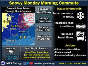
The National Weather Service has issued a winter weather advisory starting Monday morning, with up to 6 inches of snow expected across the Chicago area.
Snow could begin falling just after midnight Sunday and continue through Monday evening, the weather service forecasted. Between 3 and 6 inches of snow were expected in Lake, DuPage and Cook counties. Visibility will be reduced during periods of heavy snowfall and could make for difficult driving conditions.
“The intensity of the snow will vary from time to time until tomorrow morning,” said Gino Izzi, a meteorologist with the National Weather Service. “It seems pretty likely we’ll be experiencing snow during rush hour, so I would plan on a longer than usual commute.”
Izzi said this will be the first time Chicago has recorded at least one inch of snow since Dec. 17, 2016, marking the city’s longest streak without snow ever recorded during the winter.
Lake effect snow could then develop Monday evening and continue overnight into Tuesday, adding to snowfall accumulations, the weather service said. Lake effect snow could continue periodically throughout Tuesday.
Temperatures were expected to reach a high of about 30 degrees on Monday, the weather service said. The chance of snow was about 100 percent on Monday, with wind gusts as high as 20 mph. A high near 27 degrees was expected Tuesday, with an 80 percent chance of snow.
The winter weather advisory will be in effect from 1 a.m. to 7 p.m. Monday, followed by a lake effect snow watch into Tuesday afternoon.
The city’s Department of Streets and Sanitation announced it will deploy 287 snow plows overnight to tackle the snowy weather. the plows will focus on salting and plowing arterial routes to ensure the roads are safe before moving to neighborhood streets if necessary.
As of 11:35 p.m. Sunday, 46 flights were canceled at O’Hare International Airport and 12 were canceled at Midway International Airport, according to the Chicago Department of Aviation.
While Chicago braced for its first snowfall in months, larger snowstorms were expected on the East Coast. A blizzard watch was issued for the Boston area, with 12 to 18 inches of snow expected to fall over eastern Massachusetts as well as central and southern Rhode Island, according to the weather service.
Meteorologist Ray Stagich
WLS -AM
Thursday, March 9th, 2017
Strong wind threat gradually evading overnight. Much colder air quickly approaching our area. A little rain/wet snow looks possible Thursday with the colder air taking ove.BELOW NORMAL TEMPS LIKELY FOR THE NEXT 7 days or more.
Today | Clouds with some breaks at times…COLDER A shower of rain or wet snow possible. High around 40F. Winds NE at 10 to 15 mph.
Tonight | Cloudy early, becoming mostly clear after midnight. Low 23F. Winds NNW at 10 to 20 mph.
Tomorrow | Sunny skies. COLD…Breezy….High 28F. Winds NNW at 15 to 25 mph.
Tomorrow night | Clear during the evening followed by cloudy skies overnight. Low 17F. Winds NNW at 5 to 10 mph.
Saturday | Morning clouds followed by afternoon sun. Highs in the upper 20s and lows in the upper teens.
Sunday | More sun than clouds. Highs in the mid-30s and lows in the mid-20s.
Monday | Snow showers. Highs in the low 30s and lows in the low 20s.
Tuesday | Snow showers in the morning. Highs in the low 30s and lows in the low 20s.
Wednesday | Partly cloudy. Highs in the upper 30s and lows in the mid-20s.
Meteorologist Geoff Maurer
WLS-AM
Sunday Morning
February 26, 2017
Gusty S/SW winds will develop today.
Today | Mostly cloudy with a few flurries this morning. Turning partly cloudy 7 windy this afternoon. High 47F. Winds SSW at 20 to 30 mph with a few gusts near 40 mph.
Tonight | Partly cloudy. Low 29F. Winds SW at 10 to 15 mph.
Tomorrow | Except for a few afternoon clouds, mainly sunny. High 52F. Winds S at 10 to 15 mph.
Tomorrow night | Showers early becoming a steady light rain late. Low 42F. Winds SSE at 5 to 10 mph. Chance of rain 80%.
Tuesday | Thunderstorms developing in the afternoon. Highs in the low 60s and lows in the mid 40s.
Wednesday | Rain. Highs in the low 40s and lows in the mid 20s.
Thursday | Considerable cloudiness. Highs in the low 40s and lows in the low 20s.
(CHICAGO) As Chicago creeps toward minus 13 degrees early Monday, some people will be rooting for a record: Come on, mercury! Drop!
“Some people would say if you’re going to get this cold, you might as well set a record doing it,” National Weather Service Meteorologist Gino Izzo said Sunday night.
“Minus 14 is Chicago’s record for December 19. It was set back in 1983. We’ll probably fall just a hair short of that,” Izzo said.
Expect wind chills between minus 15 and minus 30 early Monday.
“Some people are having fun with the cold by throwing hot water into the air and watching it vaporize before hitting the ground,” Izzo said.
Temperatures should rise into the single digits Monday afternoon and continue to rise into more seasonable norms throughout the week, with highs in the 30s and lows in the teens.
Meteorologist Ray Stagich
WLS-AM Forecast
Tuesday, December 6, 2016
RAY’S NOTE: WE NOW WE BRACE FOR THE BIG CHILL LATER THIS WEEK. Easily the coldest air this fall. Wind chills in the morning THURS-FRI likely single digits.
SUNRISE AND SUNSET
DECEMBER 6 2016 – SUNRISE 705 AM CST SUNSET 420 PM CST
DECEMBER 7 2016 – SUNRISE 706 AM CST SUNSET 420 PM CST
Today | Patchy fog…(Spotty slick spots) otherwise….Mostly cloudy skies this morning will become partly cloudy this afternoon. High 36F. Winds W at 10 to 20 mph.
Tonight | A few passing clouds. Low 22F. Winds W at 10 to 20 mph.
Tomorrow | Cloudy. High around 30F. Winds WSW at 10 to 15 mph.
Tomorrow night | Evening clouds will give way to clearing. Low 16F. Winds W at 10 to 20 mph.
Thursday | More clouds than sun. Highs in the mid 20s and lows in the mid teens.
Meteorologist Ray Stagich
WLS-AM Forecast
Wednesday, September 7, 2016
IT FEELS LIKE SUMMER THIS WEEK……COOLING DOWN TOWARD THE WEEKEND (BACK TO AVERAGE)…….Some heavy downpours at times this week…..
SUNRISE AND SUNSET
SEPTEMBER 7 2016 – SUNRISE 624 AM CDT SUNSET 714 PM CDT
SEPTEMBER 8 2016 – SUNRISE 625 AM CDT SUNSET 712 PM CDT
Today | A mix of clouds and sun. A stray shower or thunderstorm is possible. High 89F. Winds SW at 10 to 20 mph.
Tonight | Thunderstorms. Low 74F. Winds SW at 10 to 20 mph. Chance of rain 80%.
Tomorrow | Cloudy skies early will become partly cloudy later in the day. A stray shower or thunderstorm is possible. High 83F. Winds W at 10 to 20 mph.
Tomorrow night | A few clouds from time to time. Low around 65F. Winds NNW at 5 to 10 mph.
Friday | Scattered thunderstorms possible. Highs in the upper 70s and lows in the upper 60s.
Saturday | Morning clouds followed by afternoon sun. Highs in the mid 70s and lows in the mid 50s.
Sunday | Sunny. Highs in the mid 70s and lows in the upper 50s.
Monday | Mainly sunny. Highs in the upper 70s and lows in the low 60s.
Tuesday | Partly cloudy with a stray thunderstorm. Highs in the mid 70s and lows in the low 60s.
Meteorologist Ray Stagich
WLS-AM
Wednesday, June 22, 2016 Heavy rain in spots first this morning. Most of it west and south. SEVERE weather with Tornadoes late today and tonight.
SUNRISE AND SUNSET
JUNE 22 2016 – SUNRISE 517 AM CDT SUNSET 831 PM CDT
JUNE 23 2016 – SUNRISE 517 AM CDT SUNSET 831 PM CDT
FFWATCH 10AM WEDNESDAY – RAINFALL RATES UP TO 1″-2″ PER HOUR POSSIBLE
Today | Variable clouds with thunderstorms – possibly severe this afternoon. Damaging winds and large hail with some storms. High 78F. SSW winds shifting to ESE at 10 to 15 mph. Chance of rain 90%.
Tonight | Thunderstorms, some strong early, then cloudy skies after midnight. Damaging winds and large hail with some storms. Low 64F. Winds NE at 10 to 15 mph. Chance of rain 80%.
Tomorrow | Cloudy skies early, followed by partial clearing. Slight chance of a rain shower. High near 75F. Winds NNE at 10 to 15 mph.
Tomorrow night | Clear skies. Low 58F. Winds NNE at 10 to 15 mph.
Friday | Sunny. Highs in the low 80s and lows in the mid 60s.
Saturday | Abundant sunshine. Highs in the low 90s and lows in the low 70s.
Sunday | Thunderstorms. Highs in the low 90s and lows in the upper 60s.
Monday | Sunny. Highs in the low 90s and lows in the mid 60s.
Tuesday | Times of sun and clouds. Highs in the mid 70s and lows in the upper 50s.
Meteorologist Ray Stagich WLS-AM Wednesday, April 27th, 2016
Ray’s Note: Clouds, windy and cool…and some rain.
SUNRISE AND SUNSET
APRIL 27 2016 – SUNRISE 552 AM CDT SUNSET 747 PM CDT
APRIL 28 2016 – SUNRISE 551 AM CDT SUNSET 748 PM CDT
Today | Becoming windy with showers developing this afternoon. High 54F. (cooler lake) Winds ENE at 20 to 30 mph. Chance of rain 40%. Winds could occasionally gust over 40 mph.
Tonight | Cloudy with periods of rain. Low 43F. Winds ENE at 15 to 25 mph. Chance of rain 70%. Rainfall around a half an inch. Winds could occasionally gust over 40 mph.
Tomorrow | Cloudy skies early. A few showers developing later in the day. High 49F. (low to mid 40 lake) Winds NE at 10 to 20 mph. Chance of rain 40%.
Tomorrow night | Cloudy. Low 41F. Winds NNE at 10 to 20 mph.
Friday | Mix of sun and clouds. Highs in the mid 50s and lows in the low 40s.
Saturday | Afternoon showers. Highs in the mid 50s and lows in the upper 40s.
Sunday | Cloudy. Highs in the upper 50s and lows in the mid 40s.
Monday | Times of sun and clouds. Highs in the low 60s and lows in the mid 40s.
Tuesday | Mix of sun and clouds. Highs in the mid 60s and lows in the upper 40s.
Meteorologist Ray Stagich WLS-AM Forecast Thursday, March 17th, 2016 Windy with an occasional shower through St. Patrick’s Day. Colder air will settle in on Friday and linger through the weekend.
PUBLIC INFORMATION STATEMENT
NATIONAL WEATHER SERVICE CHICAGO IL 354 PM CDT WED MAR 16 2016 /454 PM EDT WED MAR 16 2016/
…MAXIMUM WIND GUSTS..WEDNESDAY MARCH 16TH…
LOCATION SPEED TIME/DATE PROVIDER
VALPARAISO AIRPORT 59 MPH 0255 PM 03/16 ASOS
CHICAGO CRIB 56 MPH 1250 PM 03/16 MARITIME
PERU AIRPORT 56 MPH 1155 AM 03/16 AWOS
SUGAR GROVE – AURORA AIRPORT 55 MPH 1142 AM 03/16 ASOS
CHICAGO MIDWAY 54 MPH 0115 PM 03/16 ASOS
CHICAGO O`HARE 53 MPH 0212 PM 03/16 ASOS
DUPAGE AIRPORT 53 MPH 1253 PM 03/16 ASOS
LEWIS AIRPORT, ROMEOVILLE 52 MPH 1255 PM 03/16 AWOS
MORRIS AIRPORT 52 MPH 1135 AM 03/16 AWOS
ROCHELLE AIRPORT 52 MPH 1135 AM 03/16 AWOS
LANSING AIRPORT 51 MPH 0215 PM 03/16 AWOS
RENSSELAER AIRPORT 51 MPH 1155 AM 03/16 AWOS
ROCKFORD AIRPORT 50 MPH 0107 PM 03/16 ASOS
DE KALB AIRPORT 49 MPH 0135 PM 03/16 AWOS
BURNS HARBOR 48 MPH 1250 PM 03/16 NWS-GLOS
KANKAKEE AIRPORT 48 MPH 0115 PM 03/16 AWOS
PONTIAC AIRPORT 47 MPH 1015 AM 03/16 AWOS
WAUKEGAN AIRPORT 46 MPH 0915 AM 03/16 ASOS
WAUKEGAN HARBOR 45 MPH 1040 AM 03/16 NWS-GLOS
WHEELING – CHI EXEC AIRPORT 45 MPH 0201 PM 03/16 ASOS JOLIET AIRPORT 44 MPH 1035 AM 03/16 AWOS
OBSERVATIONS ARE COLLECTED FROM A VARIETY OF SOURCES WITH VARYING
EQUIPMENT AND EXPOSURE. NOT ALL DATA LISTED ARE CONSIDERED
OFFICIAL.
SUNRISE AND SUNSET
MARCH 17 2016 – SUNRISE 659 AM CDT SUNSET 701 PM CDT
MARCH 18 2016 – SUNRISE 657 AM CDT SUNSET 702 PM CDT
Today | A mix of clouds and sun with gusty winds. Slight chance of a rain shower. High 53F. Winds W at 25 to 35 mph.
Tonight | Mostly clear. Low 34F. Winds WNW at 10 to 15 mph.
Tomorrow | Partly cloudy skies during the morning hours will become overcast in the afternoon. High 41F. Winds NNE at 10 to 15 mph.
Tomorrow night | Partly cloudy. Low near 30F. Winds NNE at 10 to 15 mph.
Saturday | Mostly cloudy. Highs in the upper 30s and lows in the upper 20s.
Sunday | Considerable cloudiness. Highs in the mid 40s and lows in the upper 20s.
Monday | A few clouds. Highs in the low 40s and lows in the low 30s.
Tuesday | Windy with morning showers. Highs in the mid 50s and lows in the upper 40s.
(CHICAGO) Wind gusts up to nearly 60 mph could cause travel problems or property damage throughout the Chicago area Wednesday.
A high wind warning is in effect from 7 a.m. to 8 p.m. throughout Chicago and the northern and western suburbs, according to the National Weather Service. Sustained west wind speeds will be at least 40 mph, with gusts up to 58 mph or more.
The weather service said the impact of Wednesday’s winds could be comparable to the storm that hit the region Feb. 19, damaging trees and buildings and causing widespread power outages. Lightweight outdoor objects should be secured or brought indoors to prevent property damage.
High winds can also make travel difficult throughout the day Wednesday, especially for high-profile vehicles on north-to-south oriented roads, the weather service said.
Meteorologist Ray Stagich WLS-AM Thursday, July 9th, 2015 Ray’s Note: Some clearing to take place into the afternoon on Thursday. Thunderstorms will be possible from late Friday into the weekend. Warmer temps also coming out.
High yesterday: 67!!!
Rain: .07″
SUNRISE AND SUNSET
JULY 9 2015 – SUNRISE 525 AM CDT SUNSET 829 PM CDT
JULY 10 2015 – SUNRISE 525 AM CDT SUNSET 828 PM CDT
Today | Fog/Drizzle. Cloudy skies early, followed by partial clearing. Breezy. High near 75F. Winds NNE at 5 to 10 mph.
Tonight | A few passing clouds, otherwise generally clear. Low 59F. Winds SSW at 5 to 10 mph.
Tomorrow | Partly cloudy skies. A stray shower or thunderstorm is possible. High 76F. Winds ENE at 5 to 10 mph.
Tomorrow night | Partly cloudy skies. A stray shower or thunderstorm is possible. Low 62F. Winds SSE at 5 to 10 mph.
Saturday | Afternoon thunderstorms. Highs in the low 80s and lows in the upper 60s.
Sunday | Scattered thunderstorms. Highs in the low 80s and lows in the upper 60s.
Monday | Thunderstorms developing in the afternoon. Highs in the low 80s and lows in the mid 60s.
Meteorologist Ray Stagich WLS-AM 4:00AM CT Forecast Wednesday, May 20th, 2015 Ray’s Note: Looks like a cool and quiet weather pattern (lake breezes) in place through Wednesday. Latest computer models are a little more aggressive with rain chances during the later half of Memorial Day weekend. Warmer weather on the way for the weekend.
THE CHICAGO-OHARE CLIMATE NORMALS FOR TODAY
NORMAL RECORD YEAR
MAXIMUM TEMPERATURE (F) 71 95 1977
MINIMUM TEMPERATURE (F) 49 33 2002
SUNRISE AND SUNSET
MAY 20 2015 – SUNRISE 527 AM CDT SUNSET 810 PM CDT
MAY 21 2015 – SUNRISE 526 AM CDT SUNSET 811 PM CDT
Today | Overcast. Passing sprinkles and showers. High 48F. Winds NE at 5 to 10 mph.
Tonight | Cloudy skies early, then partly cloudy after midnight. Low 43F. Winds WNW at 5 to 10 mph.
Tomorrow | Sunshine and clouds mixed. High 69F. Winds WNW at 10 to 20 mph.
Tomorrow night | Mainly clear skies. Low 47F. WSW winds shifting to N at 10 to 15 mph.
Friday | More sun than clouds. Highs in the mid 60s. Cooler by the lake. Lows in the mid 40s.
Saturday | Mix of sun and clouds. Highs in the mid 70s and lows in the mid 50s.
Sunday | A few thunderstorms possible. Highs in the mid 70s and lows in the low 60s.
Monday | Showers possible. Highs in the mid 70s and lows in the low 60s.
Meteorologist Ray Stagich WLS Wednesday, May 6th, 2015 Warm air overrunning the colder ground will keep the fog forming in places this morning.
Warm weather the rest of the week, then a cool down for the weekend. Some rain and storms possible along the way. Chances go up by Friday.
**Dense Fog Advisory until 11 am CDT Wednesday**
SUNRISE AND SUNSET
MAY 6 2015………..SUNRISE 542 AM CDT SUNSET 756 PM CDT
MAY 7 2015………..SUNRISE 540 AM CDT SUNSET 757 PM CDT Today | Patchy dense fog this moring with a chance of a shower or two followed by partly cloudy skies this afternoon. Slight chance of a shower or thunderstorm. High 76F. Cooler by the lake (50s). Winds E at 5 to 10 mph. Chance of rain 30%.
Tonight | Partly cloudy skies. Low 58F. Winds SE at 5 to 10 mph.
Tomorrow | Wind increasing. A few clouds from time to time. High 84F. Winds S at 20 to 30 mph.
Tomorrow night | Partly cloudy with late night showers or thunderstorms. Low near 65F. Winds SSW at 10 to 20 mph. Chance of rain 40%.
Friday | Thunderstorms. Highs in the low 80s and lows in the low 60s.
Saturday | Cloudy, periods of rain. Highs in the low 70s and lows in the low 50s.
Sunday | Scattered thunderstorms possible. Highs in the low 70s and lows in the mid 50s.
Meteorologist Ray Stagich Tuesday, May 5th, 2015 Ray’s Note: Active springtime weather on the way at times this week. Lake breezes and waves of chilly rain at times through Tuesday evening. One to 2 inches of rain possible. A dose of heat and humidity mid to late week with storms possible. The weekend does not look pretty.
SUNRISE AND SUNSET
MAY 5 2015………..SUNRISE 543 AM CDT SUNSET 754 PM CDT
MAY 6 2015………..SUNRISE 542 AM CDT SUNSET 756 PM CDT
Today | Cloudy with occasional rain, some heavy. Mainly in the morning. Thunder possible. High around 60F. Cooler near the lake. Winds NE at 10 to 15 mph. Chance of rain 100%.
Tonight | Cloudy skies. A stray shower or thunderstorm is possible. Low 51F. Winds NE at 5 to 10 mph.
Tomorrow | Cloudy skies early, followed by partial clearing. A stray shower or thunderstorm is possible. High 78F. Cooler near the lake. Winds ESE at 5 to 10 mph.
Tomorrow night | Clear skies. Low near 60F. Winds SE at 5 to 10 mph.
Thursday | More sun than clouds. Highs in the mid 80s and lows in the mid 60s.
Friday | Showers and thunderstorms. Highs in the low 80s and lows in the low 60s.
Saturday | Mainly cloudy and rainy. Highs in the upper 60s and lows in the low 50s.
Sunday | Rain. Highs in the upper 60s and lows in the upper 50s.
Meteorologist Ray Stagich WLS Wednesday, April 29th, 2015
Cool weather hangs around through Thursday under this North-northeast flow, keeping lake front temps upper 40s to lower 50s. A little better inland. A big temperature jump right on cue with the beginning of May for Friday. Mild weather lasting into the weekend. Some Spring showers and thunderstorms possible on Sunday.
Today | Sunny to partly cloudy. Slight chance of a rain shower. High 59F. Cooler by the lake. Winds NNE at 10 to 20 mph.
Tonight | Partly cloudy. Slight chance of a rain shower. Low 38F. Winds NNE at 10 to 20 mph.
Tomorrow | Partly cloudy. High 52F. Cooler by the lake. Winds N at 10 to 20 mph.
Tomorrow night | Clear. Low 38F. Winds N at 10 to 15 mph.
Friday | Plenty of sun. Highs in the mid 60s and lows in the low 50s.
Saturday | Clouds giving way to sun . Highs in the low 70s and lows in the mid 50s.
Sunday | Scattered thunderstorms. Highs in the mid 70s and lows in the low 60s.
Meteorologist Ray Stagich
Friday, April 24th, 2015
**Frost Advisory until 8 am CDT Friday***
Chilly morning. A little milder this afternoon except along the lakefront where temps may not get out of the 40s. We are all in the 40s tomorrow. Just a nasty Saturday expected with rain and wind, also.
Today | Partly cloudy this morning, then becoming cloudy during the afternoon. High 59F. (cooler Lake) Winds ESE at 10 to 15 mph.
Tonight | A few showers this evening with overcast skies overnight. Low 43F. Winds E at 10 to 20 mph. Chance of rain 40%.
Tomorrow | Cloudy with periods of rain…which may be heavy early. Becoming windy in the afternoon. High near 45F. Winds ENE at 20 to 30 mph. Chance of rain 100%. Rainfall may reach one inch.
Tomorrow night | Cloudy skies early, then partly cloudy after midnight. Low 37F. Winds NE at 15 to 25 mph.
Sunday | Abundant sunshine. Highs in the mid 50s (cooler lake) and lows in the mid 30s.
Monday | Sunny. Highs in the mid 50s and lows in the upper 30s.
Tuesday | A few clouds. Highs in the upper 50s and lows in the low 40s.
INCLUDING THE CITIES OF…ROCKFORD…BELVIDERE…WOODSTOCK…
WAUKEGAN…OREGON…DIXON…DEKALB…AURORA…WHEATON…CHICAGO…OTTAWA…OSWEGO…MORRIS…JOLIET…KANKAKEE…PONTIAC…
WATSEKA…PAXTON…GARY…VALPARAISO…MOROCCO…RENSSELAER…FOWLER
ADVISORY IN EFFECT FROM 11 AM CDT /NOON EDT/ THIS MORNING
TO 7 PM CDT /8 PM EDT/ THIS EVENING…
THE NATIONAL WEATHER SERVICE IN CHICAGO HAS ISSUED A WIND
ADVISORY…WHICH IS IN EFFECT FROM 11 AM CDT /NOON EDT/ THIS
MORNING TO 7 PM CDT /8 PM EDT/ THIS EVENING.
* TIMING…LATE MORNING THROUGH LATE AFTERNOON TODAY.
* WINDS…WEST 25 TO 35 MPH WITH FREQUENT GUSTS TO 45 MPH. A FEW GUSTS TO 50 MPH POSSIBLE.
* IMPACTS…DRIVING CAN BECOME DIFFICULT…ESPECIALLY FOR NORTH-SOUTH ORIENTED ROADS AND HIGH PROFILE VEHICLES. SMALL TREE LIMBS ARE SUSCEPTIBLE AT WIND GUSTS OF THIS MAGNITUDE.
Tonight | Partly cloudy skies. Low 34F. Winds WNW at 15 to 25 mph.
Tomorrow | Partly cloudy. Gusty winds in the afternoon. High 52F. Winds WNW at 20 to 30 mph.
Thursday | Sunshine. Highs in the mid 50s and lows in the mid 30s.
Friday | A few clouds. Highs in the mid 50s and lows in the low 40s.
Saturday | Rain. Highs in the upper 40s and lows in the mid 30s.
Sunday | Sunny. Highs in the upper 50s and lows in the upper 30s.
(CHICAGO) The Chicago area can expect thunderstorms Wednesday evening and overnight before the brunt of a storm cell hits Thursday afternoon, possibly packing hail, strong winds and the potential for tornadoes, the Chicago Sun-Times is reporting.
“The main severe threat will come into play Thursday from about 3 p.m. to 9 p.m. with the possibility of large hail and damaging winds and the possibility of a few tornados,” said National Weather Service meteorologist Kevin Birk. “They can’t be ruled out.”
A rapid warm-up will accompany the severe weather. On Wednesday night, it was 39 degrees in the Loop. On Thursday, the temperature will rise into the 70s, Birk said
“Enhanced Risk” for severe storms on Thurs! Learn what this means on graphic. More info here: http://t.co/aWDPqzzGZQ pic.twitter.com/7ukqEJMkSc
— NWS Chicago (@NWSChicago) April 7, 2015
“There could be quarter-sized hail and larger,” Birk said. “I wouldn’t be surprised if we get a few golf ball-sized, too.”
The storms also carry the potential for flash flooding in city, with up to an inch of rain in some areas.
“It’s hard to say where the brunt will be,” Birk said. “Most of Northern Illinois is in the target area for this severe potential.”
Birk advises people to stay alert and have a plan. “Keep an eye on the sky and have plans of action if we have to issue any warnings for significant weather.”


 The winter weather advisory will be in effect from 1 a.m. to 7 p.m. Monday, followed by a lake effect snow watch into Tuesday afternoon.