
(CHICAGO)Severe winter weather will be hitting Chicago over the next week, bringing “dangerous cold” with below zero temperatures before the wind chill, according to the National Weather Service.
An arctic front is expected to hit the area Thursday, with another following next week, dropping the wind chill as low as 30 degrees below zero. The Chicagoland area may even break records for cold temperatures in January, though it’s too early to predict the exact numbers, according to the weather service.
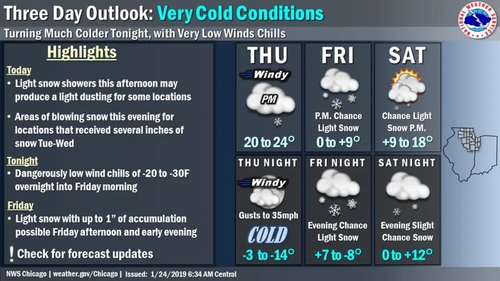
The first wave of “dangerous cold” is expected Thursday night into Friday morning, according to meteorologist Gino Izzi.
Thursday night, temperatures downtown may reach 5 degrees below zero and the western and northern suburbs may see temperatures as low as 10 to 15 degrees below zero, according to the NWS.
High winds will continue through Friday morning, when the wind chill will be as low as minus 30, according to the NWS.
“Friday morning is going to be a particularly ugly one for commuters and kids at the bus stop,” Izzi said.
Though we will experience less wind Friday during the day, it won’t warm up much.
Chicago may reach single-digit temperatures, but the northern suburbs will struggle to even reach zero degrees, Izzi said.
The weather service noted that the low temperatures and wind chills could cause frostbite on exposed skin in as little as 30 minutes. Anyone going outdoors during the extreme cold should wear a hat and gloves to reduce the risk of frostbite and hypothermia.
Up to an inch of snow is possible Friday afternoon or evening, according to the weather service.
A bigger storm expected Sunday night will dump a “shovelable” amount of snow on the Chicagoland area, Izzi said.
The snowstorm will help things warm up a bit — temperatures Monday should climb into the 20s but will drop back to below zero by Tuesday, when another arctic front may bring some of the coldest temperatures we’ve seen in years, Izzi said.