Tag Archives: thunderstorms

WEATHER – Windy, Cloudy this morning with thunderstorms developing this afternoon. High 73F

Forecast Summary

Meteorologist Ray Stagich
WLS-AM
Monday, April 10th, 2017

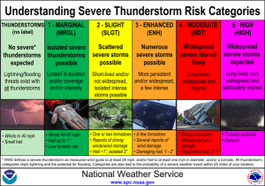
AS LOW-PRESSURE APPROACHES FROM THE WEST, SHOWER AND THUNDERSTORM CHANCES RAMP UP AS MONDAY PROGRESSES. STORMS MAY REACH SEVERE STATUS WITH LARGE HAIL AND DAMAGING WINDS THE MAIN THREATS.

THE CHICAGO-OHARE CLIMATE NORMALS FOR TODAY
NORMAL RECORD YEAR
MAXIMUM TEMPERATURE (F) 57 90 1930
MINIMUM TEMPERATURE (F) 37 18 1989

SUNRISE AND SUNSET
APRIL 10 2017………SUNRISE 619 AM CDT SUNSET 727 PM CDT
APRIL 11 2017………SUNRISE 617 AM CDT SUNSET 729 PM CDT

Today | Windy, Cloudy this morning with thunderstorms developing this afternoon. A few storms may be severe, with hail, wind and heavy rain….. High 73F. Winds SW at 15 to 25 mph. Chance of rain 80%.

Tonight | Showers early, then partly cloudy overnight. Thunder is possible early. Low 41F. Winds NW at 10 to 15 mph. Chance of rain 50%.

Tomorrow | A mix of clouds and sun early, then becoming cloudy later in the day. High 56F. Winds WNW at 10 to 15 mph.

Tomorrow night | Some clouds early will give way to generally clear conditions overnight. Low 37F. Winds SW at 5 to 10 mph.

Wednesday | Times of sun and clouds. Highs in the low 60s and lows in the upper 40s.

Thursday | Morning light rain. Highs in the mid-60s and lows in the mid-40s.

Friday | Considerable cloudiness. Highs in the mid-60s and lows in the upper 50s.

Saturday | Windy with morning thunderstorms. Highs in the upper 70s and lows in the low 60s.

Sunday | Clouds giving way to sun. Highs in the upper 60s and lows in the mmid-40s

WEATHER – Thunderstorms developing west to east mid morning…then cloudy skies this afternoon. High 79F.

Forecast Summary

Meteorologist Ray Stagich
WLS-AM Forecast
Friday, September 16, 2016

Some rain possible Friday and Saturday. Dry weather for Sunday, and cooler again…

SUNRISE AND SUNSET
SEPTEMBER 16 2016 – SUNRISE 633 AM CDT SUNSET 658 PM CDT
SEPTEMBER 17 2016 – SUNRISE 634 AM CDT SUNSET 657 PM CDT

Today | Thunderstorms developing west to east mid morning…then cloudy skies this afternoon. High 79F. Winds S at 10 to 20 mph. Chance of rain 80%.

Tonight | Variable clouds with scattered thunderstorms. Low 67F. Winds SW at 10 to 15 mph. Chance of rain 60%.

Tomorrow | Mostly cloudy…isolated thunderstorms developing during the afternoon. High 79F. Winds WSW at 10 to 20 mph. Chance of rain 30%.

Tomorrow night | Mainly clear skies. Low 58F. Winds W at 5 to 10 mph.

Sunday | A few clouds. Highs in the upper 70s and lows in the low 60s.

Monday | Mainly sunny. Highs in the low 80s and lows in the low 60s.

Tuesday | Mainly sunny. Highs in the low 80s and lows in the low 60s.

Wednesday | Times of sun and clouds. Highs in the low 80s and lows in the upper 60s.

Thursday | Mix of sun and clouds. Highs in the low 80s and lows in the upper 60s.

WEATHER – Cloudy with fog early and scattered thunderstorms developing later. High 83F.

Forecast Summary

Meteorologist Jeff Eno
WLS-AM Forecast
Tuesday, August 30, 2016

PARTS OF BOONE – DEKALB AND MCHENRY REMAIN UNDER A FLOOD WARNING AFTER HEAVY RAIN FELL ON MONDAY

DEEP MOISTURE IN PLACE…ANY STORMS MAY PRODUCE HEAVY RAIN

Monday at O’Hare:
High: 86
Low: 70
AVG: 80 / 61
Rainfall at O’Hare: 0.41″

Today | Cloudy with fog early…scattered thunderstorms developing later. High 83

Tonight | Scattered thunderstorms mainly before midnight. Low 69

Wednesday | Early clouds then gradual clearing. A stray shower or thunderstorm is possible. Highs in the middle to upper 70’s

Thursday | Times of sun and clouds. High 73

Friday | Mainly sunny. High 75

Saturday | A few clouds. High 78

WEATHER – Sunshine and clouds mixed. Showers and Thunderstorms south. High 81F.

Forecast Summary

Meteorologist Ray Stagich
WLS-AM Forecast
Friday, August 26, 2016

Storm chances could return this weekend. Staying on the warm and humid side.

SUNRISE AND SUNSET
AUGUST 26 2016 – SUNRISE 612 AM CDT SUNSET 734 PM CDT
AUGUST 27 2016 – SUNRISE 613 AM CDT SUNSET 732 PM CDT

Today | Sunshine and clouds mixed. Showers and thunderstorms south….High 81F. Winds NE at 5 to 10 mph.

Tonight | Mostly cloudy this evening. Scattered thunderstorms developing after midnight. Low 69F. Winds ENE at 5 to 10 mph. Chance of rain 60%.

Tomorrow | Scattered showers and thunderstorms. High 82F. Winds S at 10 to 15 mph. Chance of rain 60%.

Tomorrow night | Partly to mostly cloudy skies with scattered thunderstorms before midnight. Low 68F. Winds SW at 5 to 10 mph. Chance of rain 40%.

Sunday | Thunderstorms developing in the afternoon. Highs in the mid 80s and lows in the upper 60s.

Monday | Mix of sun and clouds. Highs in the mid 80s and lows in the upper 60s.

Tuesday | Times of sun and clouds. Highs in the mid 80s and lows in the upper 60s.

Wednesday | Plenty of sun. Highs in the low 80s and lows in the mid 60s.

Thursday | More sun than clouds. Highs in the low 80s and lows in the low 60s.

WEATHER – Thunderstorms during the morning will give way to partly cloudy skies this afternoon. High 79F.

Forecast Summary

Meteorologist Ray Stagich
WLS-AM
Thursday, August 25, 2016

Another slow drive this morning with local heavy rain, but drier weather for the afternoon commute. Dry on Friday before another round of rain during the weekend.

SUNRISE AND SUNSET
AUGUST 25 2016 – SUNRISE 610 AM CDT SUNSET 736 PM CDT
AUGUST 26 2016 – SUNRISE 611 AM CDT SUNSET 734 PM CDT

Today | Thunderstorms during the morning will give way to partly cloudy skies this afternoon. High 79F. Winds WNW at 5 to 10 mph. Chance of rain 80%.

Tonight | A few passing clouds. Low 63F. Winds WNW at 5 to 10 mph.

Tomorrow | Intervals of clouds and sunshine. High 82F. Winds ENE at 5 to 10 mph.

Tomorrow night | Cloudy in the evening with scattered thunderstorms developing after midnight. Low 66F. Winds E at 5 to 10 mph. Chance of rain 60%.

Saturday | Scattered thunderstorms possible. Highs in the low 80s and lows in the upper 60s.

Sunday | Isolated thunderstorms. Highs in the low 80s and lows in the upper 60s.

Monday | Mix of sun and clouds. Highs in the low 80s and lows in the mid 60s.

Tuesday | Times of sun and clouds. Highs in the mid 80s and lows in the mid 60s.

Wednesday | More sun than clouds. Highs in the low 80s and lows in the mid 60s.

WEATHER – Isolated showers and thunderstorms during the morning. Mostly cloudy skies this afternoon. High 88F.

Forecast Summary

Meteorologist Ray Stagich
WLS-AM
Friday, August 19, 2016

An active pattern in store with more storms returning Friday Night into Saturday. Some storms on Saturday Could be severe as the main cold front connected to this weather pattern sweeps across our area…

Much more pleasant Sunday into early next week….

**FLASH FLOOD WATCH FOR CHICAGO’S OUTER NORTH AND WESTERN SUBURBS UNTIL 6 AM CDT FRIDAY MORNING**
(COUNTIES INCLUDED: KANE,WILL & DEKALB IN THE CHICAGO METRO AREA)
THIS WATCH INCLUDES: JOLIET, NAPERVILLE AND KANKAKEE…

SUNRISE AND SUNSET
AUGUST 19 2016 – SUNRISE 604 AM CDT SUNSET 745 PM CDT
AUGUST 20 2016 – SUNRISE 605 AM CDT SUNSET 744 PM CDT

Today | Isolated showers and thunderstorms during the morning. Mostly cloudy skies this afternoon. High 88F. Winds SW at 10 to 15 mph. Chance of rain 30%.

Tonight | Partly to mostly cloudy skies with scattered thunderstorms mainly during the evening. Low 71F. Winds SSW at 10 to 15 mph. Chance of rain 40%.

Tomorrow | Scattered thunderstorms in the morning becoming more widespread in the afternoon. A few storms may be severe. High 78F. Winds SSW at 10 to 20 mph. Chance of rain 80%.

Tomorrow night | Some clouds early will give way to generally clear conditions overnight. Low around 60F. Winds W at 10 to 20 mph.

Sunday | Mix of sun and clouds. Highs in the mid 70s and lows in the upper 50s.

Monday | Plenty of sun. Highs in the upper 70s and lows in the low 60s.

Tuesday | Sunny. Highs in the low 80s and lows in the low 60s.

Wednesday | More sun than clouds. Highs in the low 80s and lows in the upper 60s.

Thursday | Scattered thunderstorms. Highs in the low 80s and lows in the mid 60s.

WEATHER – Sun and clouds mixed. High 88F.

Forecast Summary

Meteorologist Ray Stagich
WLS-AM Morning Forecast
Tuesday, August 9, 2016

SUMMERTIME HEAT AND HUMIDITY RETURNING BY MIDWEEK AS HIGH PRESSURE SLIDES OFF TO OUR EAST. THE HEAT INDEX IS EXPECTED TO REACH AS HIGH AS THE UPPER 90S WEDNESDAY WITH THE THREAT FOR SCATTERED AFTERNOON SHOWERS AND STORMS LATE WEEK.

SUNRISE AND SUNSET
AUGUST 9 2016 – SUNRISE 554 AM CDT SUNSET 800 PM CDT
AUGUST 10 2016 – SUNRISE 555 AM CDT SUNSET 758 PM CDT

Today | Sun and clouds mixed. High 88F. Cooler by the lake. Winds SSE at 5 to 10 mph.

Tonight | Partly cloudy skies. Low near 70F. Winds SE at 5 to 10 mph.

Tomorrow | Mostly sunny skies. High 89F. Winds E at 5 to 10 mph.

Tomorrow night | Partly cloudy. A stray shower or thunderstorm is possible. Low 74F. Winds SE at 5 to 10 mph.

Thursday | Times of sun and clouds. Highs in the low 90s and lows in the mid 70s.

Friday | Showers and thunderstorms. Highs in the upper 80s and lows in the low 70s.

Saturday | Mix of sun and clouds. Highs in the low 80s and lows in the mid 60s.

Sunday | Mix of sun and clouds. Highs in the low 80s and lows in the mid 60s.

Monday | Partly cloudy. Highs in the low 80s and lows in the low 60s.

WEATHER – Damaging winds and large hail with some storms. High 78F.

Forecast Summary

Meteorologist Ray Stagich
WLS-AM
Wednesday, June 22, 2016

Heavy rain in spots first this morning. Most of it west and south. SEVERE weather with Tornadoes late today and tonight.

SUNRISE AND SUNSET
JUNE 22 2016 – SUNRISE 517 AM CDT SUNSET 831 PM CDT
JUNE 23 2016 – SUNRISE 517 AM CDT SUNSET 831 PM CDT

FFWATCH 10AM WEDNESDAY – RAINFALL RATES UP TO 1″-2″ PER HOUR POSSIBLE

Today | Variable clouds with thunderstorms – possibly severe this afternoon. Damaging winds and large hail with some storms. High 78F. SSW winds shifting to ESE at 10 to 15 mph. Chance of rain 90%.

Tonight | Thunderstorms, some strong early, then cloudy skies after midnight. Damaging winds and large hail with some storms. Low 64F. Winds NE at 10 to 15 mph. Chance of rain 80%.

Tomorrow | Cloudy skies early, followed by partial clearing. Slight chance of a rain shower. High near 75F. Winds NNE at 10 to 15 mph.

Tomorrow night | Clear skies. Low 58F. Winds NNE at 10 to 15 mph.

Friday | Sunny. Highs in the low 80s and lows in the mid 60s.

Saturday | Abundant sunshine. Highs in the low 90s and lows in the low 70s.

Sunday | Thunderstorms. Highs in the low 90s and lows in the upper 60s.

Monday | Sunny. Highs in the low 90s and lows in the mid 60s.

Tuesday | Times of sun and clouds. Highs in the mid 70s and lows in the upper 50s.

WEATHER – Damaging winds and large hail with some storms. High 88F.

Meteorologist Ray Stagich
WLS Weather Forecast
Monday, July13th, 2015

StormRisk-CST-0409151-300x210

FLASH FLOOD WATCH IS IN EFFECT FROM 1AM MONDAY THROUGH LATE MONDAY NIGHT.

SEVERE THUNDERSTORM WATCH OUTLINE UPDATE FOR WS 408
NWS STORM PREDICTION CENTER NORMAN OK
410 AM CDT MON JUL 13 2015

SEVERE THUNDERSTORM WATCH 408 IS IN EFFECT UNTIL 1000 AM CDT FOR THE FOLLOWING LOCATIONS IL. ILLINOIS COUNTIES INCLUDED ARE:
BOONE BUREAU CARROLL
COOK DE KALB DUPAGE
GRUNDY JO DAVIESS KANE
KENDALL LAKE LA SALLE
LEE MCHENRY OGLE
PUTNAM STEPHENSON WHITESIDE
WILL WINNEBAGO

2 ROUNDS OF POTENTIALLY SEVERE STORMS. THE FIRST INTO PARTS OF MONDAY MORNING; THE SECOND ROUND MONDAY AFTERNOON/EVENING.

LARGE HAIL, DAMAGING WINDS, FLASH FLOODING POSSIBLE IN BOTH THESE EVENTS. ISOLATED TORNADOES ALSO POSSIBLE DURING THE PM HOURS MONDAY.

More storms possbile on Tuesday…..

SUNRISE AND SUNSET
JULY 13 2015 – SUNRISE 5:28 AM CDT SUNSET 8:27 PM CDT
JULY 14 2015 – SUNRISE 5:28 AM CDT SUNSET 8:26 PM CDT

Today | Strong thunderstorms likely. Damaging winds and large hail with some storms. Heavy rain coming in two rounds….one in the morning and one this afternoon. High 88F. Winds SSW at 10 to 15 mph. Chance of rain 100%. Rainfall near an inch. With locally higher totals.

Tonight | Partly to mostly cloudy skies with scattered thunderstorms during the evening. A few storms may be severe. Low 69F. Winds WSW at 10 to 15 mph. Chance of rain 60%.

Tomorrow | Scattered thunderstorms in the morning becoming more widespread in the afternoon. High 81F. Winds NNW at 10 to 15 mph. Chance of rain 80%.

Tomorrow night | A few clouds. Low around 60F. Winds NNE at 10 to 15 mph.

Wednesday | A few clouds. Highs in the mid 70s and lows in the upper 50s.

Thursday | Mix of sun and clouds. Highs in the low 80s and lows in the mid 60s.

Friday | Scattered thunderstorms. Highs in the mid 80s and lows in the upper 60s.


WLS Traffic HQ
https://www.wlsam.com/traffic-center/

Thunderstorms, possibly severe, expected Saturday night and all day Sunday

(Chicago) The National Weather Service has issued a hazardous weather outlook with severe thunderstorms expected throughout the Chicago area this weekend.

Periodic thunderstorms are possible throughout the region from Saturday night through early Monday, according to the weather service. The storms could be strong or severe, and produce heavy rainfall, especially on Sunday.

Saturday will be mostly sunny with a high of 68 degrees, according to the weather service. Rainfall is expected to start overnight. Sunday will be warmer, with a high of 81 degrees, and showers and thunderstorms likely throughout the day.

The storms could continue into Monday morning, but the rest of Monday should be mostly sunny with a high near 83 degrees.

Keep track of changing weather conditions here, on the new WLS Wearher Page. .

WEATHER – Partly cloudy, breezy. Highs mid 60s all day.

Meteorologist Ray Stagich
WLS-AM
Friday, June 5th, 2015

Ray’s Note: Cooler weather ahead today. A surge of warmth and humidity for the late weekend with Sunday t-storms possible. A few of them possibly severe. Drying out again on Monday.

Today | Partly cloudy, breezy. Highs mid 60s all day. Cooler by the lake. Winds NNE at 10 to 20 mph.

Tonight | A few clouds. Low 53F. Winds NNE at 10 to 20 mph.

Tomorrow | Sunshine and clouds mixed. High 71F. Cooler by the lake. Winds ENE at 10 to 15 mph.

Tomorrow night | Mostly cloudy with some showers late. Low around 60F. Winds SE at 10 to 15 mph. Chance of rain 50%.

Sunday | Thunderstorms. Potential for severe thunderstorms. Highs in the low 80s and lows in the low 60s.

Monday | Plenty of sun. Highs in the low 80s and lows in the low 60s.

Tuesday | A few clouds. Highs in the mid 80s and lows in the upper 60s.

WEATHER – Scattered showers and thunderstorms. High 81F.

Meteorologist Ray Stagich
WLS-AM
Friday, May 29th, 2015

Ray’s Note: Somewhat of an active weather pattern returning today and into the start of the weekend. A big cool down for the last weekend of May with FALLING temps during the afternoon and evening on Saturday.

SUNRISE AND SUNSET
MAY 29 2015 – SUNRISE 520 AM CDT SUNSET 818 PM CDT
MAY 30 2015 – SUNRISE 520 AM CDT SUNSET 819 PM CDT

Today | Scattered showers and thunderstorms. High 81F. Winds SSW at 10 to 20 mph. Chance of rain 50%.

Tonight | Mostly cloudy with showers and a possible thunderstorm especially late. Low near 65F. Winds SW at 10 to 15 mph. Chance of rain 80%.

Tomorrow | Cloudy with rain ending in the afternoon. Windy at times late. High 66F and falling possibly into the 40s by evening!!!!
Winds NNE at 20 to 30 mph. Chance of rain 70%. Rainfall near a quarter of an inch.

Tomorrow night | Partly cloudy. Windy. Low 43F. Winds NNE at 20 to 30 mph.

Sunday | Times of sun and clouds. Highs in the upper 50s and lows in the mid 40s.

Monday | Times of sun and clouds. Highs in the mid 60s and lows in the low 50s.

Tuesday | Plenty of sun. Highs in the mid 70s and lows in the upper 50s.

WEATHER – Scattered thunderstorms developing. High 70°F.

Meteorologist Ray Stagich
Monday, May 11th, 2015

Ray’s Note: Scattered thunderstorms developing SW to NE this morning. Some heavy rain and large hail and damaging winds in spots.

SUNRISE AND SUNSET
MAY 11 2015………..SUNRISE 536 AM CDT SUNSET 801 PM CDT
MAY 12 2015………..SUNRISE 535 AM CDT SUNSET 802 PM CDT

Today | Areas of dense morning fog. Variable clouds with showers and scattered thunderstorms. High around 70F. Winds SW at 15 to 25 mph. Windy at times. Chance of rain 70%.

Tonight | A few clouds. Windy Low 47F. Winds WSW at 15 to 25 mph.

Tomorrow | Windy and partly cloudy early. Mostly cloudy with diminishing winds later in the day. High 59F. Winds W at 20 to 30 mph.

Tomorrow night | Partly cloudy skies. Low 41F. Winds NNW at 10 to 20 mph.

Wednesday | Sunshine. Highs in the upper 50s and lows in the low 40s.

Thursday | Showers possible in the afternoon. Highs in the mid 60s and lows in the mid 50s
.
Friday | Showers. Highs in the low 70s and lows in the low 50s.

WEATHER – Fog, scattered showers and a chance of a storm. High 81F.

Meteorologist Ray Stagich
Friday, May 8th, 2015
Ray’s Note: Showers and thunderstorms possible this morning. Best chance of any severe weather will stay over Missouri SW of St. Louis back down into the very stormy plains overnight. Any storms that cross our area tonight could have some brief heavy rain. Mother’s Day weekend could be rainy at times.

A strong shot of energy in the jet stream and cold front moving into the midwest and plains early next week could jump start our severe weather potential for Monday into Monday Night. Stay tuned for more on this over the next few days.

SUNRISE AND SUNSET
MAY 8 2015………..SUNRISE 539 AM CDT SUNSET 758 PM CDT
MAY 9 2015………..SUNRISE 538 AM CDT SUNSET 759 PM CDT

Today | Some fog and a few showers with scattered thunderstorms this morning. Mainly cloudy during the afternoon with thunderstorms likely again. High 81F. Winds SW at 10 to 15 mph. Chance of rain 80%.

Tonight | Showers and thundershowers this evening, then cloudy with rain likely overnight. Low 56F. Winds SE at 5 to 10 mph. Chance of rain 100%.

Tomorrow | Overcast. High 61F. Cooler by the lake. Winds NNE at 10 to 15 mph.

Tomorrow night | Increasing clouds with showers arriving sometime after midnight. Low 47F. Winds NE at 10 to 15 mph. Chance of rain 40%.

Sunday | Rain and thunder. Highs in the mid 70s and lows in the upper 50s.

Monday | Thunderstorms. Potential for severe thunderstorms. Highs in the low 70s and lows in the low 50s.

Tuesday | A few clouds. Highs in the low 60s and lows in the low 40s.

WEATHER – A few storms may be severe. High 71F.

Meteorologist Ray Stagich
Monday, May 4th, 2015

Thunderstorms could contain heavy rainfall. Some strong to severe storms possible Monday with wind and small hail.

SUNRISE AND SUNSET
MAY 4 2015………..SUNRISE 544 AM CDT SUNSET 753 PM CDT
MAY 5 2015………..SUNRISE 543 AM CDT SUNSET 754 PM CDT

Today | Variable clouds with scattered thunderstorms. A few storms may be severe. High 71F. Cooler by the lake. WSW winds shifting to NNE at 10 to 20 mph. Chance of rain 60%.

Tonight | Cloudy with rain developing after midnight. Low 49F. Winds NE at 10 to 15 mph. Chance of rain 70%. Rainfall around a quarter of an inch.

Tomorrow | Cloudy. Periods of rain early. Thunder possible. High 62F. Cooler by the lake. Winds NE at 10 to 15 mph. Chance of rain 80%.

Tomorrow night | Cloudy with occasional showers. Thunder possible. Low 52F. Winds ENE at 5 to 10 mph. Chance of rain 40%.

Wednesday | Clouds giving way to sun . Highs in the upper 70s (cooler lake) and lows in the low 60s.

Thursday | More sun than clouds. Highs in the mid 80s and lows in the mid 60s.

Friday | Afternoon showers and thunderstorms. Highs in the low 80s and lows in the low 60s.

WEATHER – A mix of clouds and sun. High 52F.

Meteorologist Ray Stagich
WLS
Thursday, April 30th, 2015

Cool weather hangs around through Thursday under this North-northeast flow. Keeping lake front temps upper 40s to lower 50s. A little better inland. A big temperature jump right on cue with the beginning of May for Friday. Mild weather lasting into the weekend.

Today | A mix of clouds and sun. High 52F. Winds NNE at 15 to 25 mph.

Tonight | A clear sky. Low 39F. Winds N at 10 to 15 mph.

Tomorrow | Sunny, along with a few afternoon clouds. High 67F. Winds NE at 5 to 10 mph.

Tomorrow night | Considerable clouds early. Some decrease in clouds late. Low around 50F. Winds SSW at 5 to 10 mph.

Saturday | Times of sun and clouds. Highs in the low 70s and lows in the mid 50s.

Sunday | Mix of sun and clouds. Highs in the upper 70s and lows in the low 60s.

Monday | Showers and thunderstorms. Highs in the low 70s and lows in the low 50s.