


How much snow are you going to be waking up to tomorrow morning? Head to the Bruce St James Show page to hear Weather Channel meteorologist Ray Stagich’s full weather update.
Tag Archives: snow
The Steve Dahl Show – February 9, 2018 – Sample
Happy Friday subscribers! Due to the winter storm papa is recording from home today! Dag talks about his hotel stay last night downtown. Rosie Dahl and Steve are home alone this weekend. The boys talk life hacks, plus your calls!
The Steve Dahl Show – January 16, 2018 – Sample
Steve, Brendan, and Dag are finally back from their Mexico Trip! Steve talks getting sick during the week long work trip and not being able to find saltines! Dag and Brendan discuss their eventful trip back to the states…oy vey! Welcome back boys!
Lake-effect system dumps nearly 8 inches of snow on Chicago
(CHICAGO) After two days of pummeling by a lake-effect system, nearly 8 inches of snow had piled up in Chicago by Tuesday evening.
A lake-effect snow warning remains in effect until 10 a.m. Wednesday in northwest Indiana, which could see up to a foot of snow in parts of Porter County, according to the National Weather Service.
As of 7 p.m. Tuesday, 7.7 inches of snow was measured at O’Hare International Airport dating back to Sunday night, forecasters said. At Midway International Airport, 7.3 inches were recorded. Most of that snow fell from Monday night into Tuesday morning.
Some northern suburbs in Lake County including Waukegan and Zion saw more than a foot of snow, while about 8 inches were measured in southwest suburban Oak Lawn. The lake-effect system had mostly moved out of the Chicago area by 5 p.m.
As the snow settled, 920 flights were canceled at O’Hare as of 8:45 p.m. Tuesday. Seventy-one were grounded at Midway, with minimal delays at both airports.
Wednesday is expected to be clear and sunny with a high of 28 degrees, before temperatures return to the 30s and 40s late in the week, forecasters said. There is a slight chance of snow on Thursday night before a rainy Friday morning.
WEATHER – Sunshine and clouds mixed. A few flurries are possible. Breezy and cold. High 32F.
Forecast Summary
Meteorologist Ray Stagich
Wednesday, March 15th, 2017
WLS-AM
INDIANA COUNTIES REMAIN UNDER THE LAKE EFFECT SNOW WARNINGS AND ADVISORIES…TEMPS STAY VERY COLD INTO THURSDAY
Today | Sunshine and clouds mixed. A few flurries are possible. Breezy and cold… High 32F. Winds NW at 10 to 20 mph.
Tonight | Partly cloudy skies. Low 13F. Winds W at 5 to 10 mph.
Tomorrow | Sunshine and clouds mixed. High 39F. Winds SW at 10 to 15 mph.
Tomorrow night | Overcast with rain showers at times. Low 33F. Winds SSE at 10 to 15 mph. Chance of rain 50%.
Friday | Showers. Highs in the mid-40s and lows in the mid-30s.
Saturday | Considerable cloudiness. Highs in the low 40s and lows in the mid-20s.
Sunday | Sunshine. Highs in the mid-40s and lows in the low 30s.
Monday | Afternoon showers. Highs in the mid-50s and lows in the mid-30s.
Tuesday | More sun than clouds. Highs in the low 50s and lows in the mid-20s.
Open Letter as a Reminder to Shovel Your Sidewalk from Alderman Joe Moore
Dear Neighbor,
Winter certainly came early this year, with both snow and bitter cold. So it’s time remind everyone that city ordinance requires homeowners and business owners to shovel the sidewalks adjacent to their property. Not only is it the neighborly thing to do, but failure to do so can result in a fine of up to $500.
And though it’s bitter cold now, the temperature is forecast to get near the freezing mark Friday and Saturday. If you haven’t shoveled yet, those are good days to get out there and get it done.
We all need to do our part. I always shovel the walk in front of my home and make sure the snow is cleared in front of the 49th Ward Service Office.
If you know of a property where the sidewalk is not shoveled within 24 hours after a snowfall ends, contact my office at [email protected] or call 773-338-5796 and provide us with the address of the property.
We’ll issue a warning and subsequently a ticket, if necessary.
Of course, I realize some people are not physically able to shovel snow. If you are 60 years of age or older and/or have a physical disability and lack access to available resources (financial resources or local family/friends), you are eligible to sign up for the Chicago Snow Corps.
The Snow Corps is a City referral program that uses 311 to connect volunteers willing to shovel snow with people who are in need of assistance. Simply call 311 and ask to be placed on the program list.
Please note there is no guarantee by requesting volunteer snow shoveling that you will receive assistance. This program is based on the number of volunteers who sign up.
Visit the city sign-up page to volunteer to shovel the sidewalk of a senior citizen or disabled neighbor.If you can afford to pay someone to shovel your walk, my office has a list of people willing to shovel your walk for a reasonable charge. Please reply to this e-mail or call 773-338-5796 and we will provide you with their contact information.
In addition to the Snow Corps program, the City now has a real-time “Plow Tracker” map that allows residents to monitor the progress of the City’s snow plows during major snow cleanup efforts.
Thanks in advance for being a good neighbor and keeping our neighborhood walkable in the winter.
Sincerely,
Joe Moore
Source: Shovel your sidewalk and keep our neighborhood walkable | Ward 49
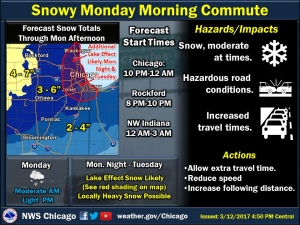
10 inches of snow possible as lake-effect system moves in
(CHICAGO) Mother Nature is making a mid-March push to turn an unseasonably warm, dry winter in Chicago into something a little more seasonable.
Up to 10 inches of snow could pile up by midday Tuesday as a lake-effect snow system that started Monday night moves through the Chicago area, according to the National Weather Service. The lake-effect warning is in effect until 4 p.m. Tuesday in Cook, DuPage and Lake counties.
Chicago’s 287 snow plows hit the streets Monday night, clearing main arteries before heading to residential blocks, according to the city’s Dept. of Streets and Sanitation. Residents can monitor the snow plow fleet in real time on the city’s website.
The lake-effect band had accumulated 1.8 inches of snow at O’Hare International Airport by 1 a.m. Tuesday, bringing this winter’s snowfall total to about 22.7 inches, forecasters said.
That number is well below the seasonal average of 32.2 inches, which could be within striking distance if the lake-effect system packs its full punch.
The lake-effect band that started between 7 and 8 p.m. Monday in the northern suburbs had dropped 8.5 inches in Waukegan by early Tuesday, NWS meteorologist Casey Sullivan said. That band moved into northern Cook County by 4:45 a.m., and another band was expected to form somewhere in the area later in the morning.
Between 5 and 10 inches are expected, with especially “intense” snowfall overnight — up to 2 inches per hour in the most directly hit areas — making for a nightmarish morning commute, forecasters said. But because lake-effect bands are only about 10 to 15 miles wide, snow totals can greatly vary over short distances.
Slick road conditions Monday night were thought to be the culprit of two separate chain-reaction crashes, involving a total of 35 vehicles, in the inbound express lanes of Interstate 90/94 between North Avenue and Division Street. Seven people were taken to the hospital with injuries that were not thought to be life-threatening, while 23 people refused medical attention.
As of 4:50 a.m. Tuesday, 340 flights had been canceled at O’Hare, and 65 were grounded at Midway International Airport, according to the city’s Department of Aviation. Delays at both airports were averaging less than 15 minutes.
In the months of January and February, not an inch of snow accumulation was recorded in Chicago — a first in recorded history. Before Monday, the last snowfall greater than an inch during this unseasonably warm winter occurred on Dec. 17 when 1.7 inches accumulated in Chicago.
While Chicago braced for its first snowfall in months, larger snowstorms were expected on the East Coast. A blizzard watch was issued for the Boston area, with 12 to 18 inches of snow expected to fall over eastern Massachusetts as well as central and southern Rhode Island, according to the weather service.
WEATHER – Windy & cold with snow continuing. High near 25F.
Forecast Summary
Meteorologist Geoff Maurer
Tuesday, March 14th, 2017
**A LAKE EFFECT SNOW WARNING REMAINS IN EFFECT UNTIL 4 PM CDT TODAY FOR COOK, DUPAGE AND LAKE COUNTIES IN IL. AND LAKE COUNTY IN INDIANA. 3-7″ OF SNOW IS POSSIBLE WITH GUSTY NORTH WINDS REDUCING VISIBILITY AT TIMES.**
Today | Windy & cold with snow continuing. High near 25F. Winds N at 20 to 30 mph. Chance of snow 100%. Snow accumulating 3 to 7 inches.
Tonight | A few flurries this evening then clearing late. Low around 15F. Winds NNW at 10 to 20 mph.
Tomorrow | Mostly sunny. High 31F. Winds NW at 10 to 20 mph.
Tomorrow night | Partly cloudy. Low 16F. Winds W at 5 to 10 mph.
Thursday | Mix of sun and clouds. Highs in the low 40s and lows in the low 30s.
Friday | Rain. Highs in the low 50s and lows in the low 30s.
Saturday | Windy with a mix of sun and clouds. Highs in the mid 40s and lows in the upper 20s.
Sunday | Mostly sunny. Highs in the low 40s and lows in the mid 30s.
Today Can Kill You, So Just Stay Home
From the International Business Times, various things are happening after the annual time change in March.
Studies have found that sleep-deprived humans are likely to have more irritability and mood swings.
April 2016 showed that there was a significant increase of about 6 percent in the number of car crashes after time change than before.
Another 2016 study on the risks of stroke during daylight saving time discovered that the rate of stroke increased by 8 percent within two days of the time change. During this time, cancer victims were 25 percent more susceptible to have a stroke and people over the age of 65 years were 20 percent more prone to strokes than others.
Now add to this the many inches of snow blanketing the Chicago area, it might be ideal to just stay home in bed all day. Roughly 100 people in America die shoveling snow each year.
A study looking at data from 1990 to 2006 by researchers at the US Nationwide Children’s Hospital recorded 1,647 fatalities from cardiac-related injuries associated with shovelling snow. In Canada, these deaths make the news every winter.
Source: How Is Daylight Saving Time Bad For Health? Tips To Avoid Risks
Source: Why do so many people die shoveling snow?
Up to 6 inches of snow could fall Monday over Chicago

UPDATES WITH DETAILS, SNOW PLOWS DEPLOYED
The National Weather Service has issued a winter weather advisory starting Monday morning, with up to 6 inches of snow expected across the Chicago area.
Snow could begin falling just after midnight Sunday and continue through Monday evening, the weather service forecasted. Between 3 and 6 inches of snow were expected in Lake, DuPage and Cook counties. Visibility will be reduced during periods of heavy snowfall and could make for difficult driving conditions.
“The intensity of the snow will vary from time to time until tomorrow morning,” said Gino Izzi, a meteorologist with the National Weather Service. “It seems pretty likely we’ll be experiencing snow during rush hour, so I would plan on a longer than usual commute.”
Izzi said this will be the first time Chicago has recorded at least one inch of snow since Dec. 17, 2016, marking the city’s longest streak without snow ever recorded during the winter.
Lake effect snow could then develop Monday evening and continue overnight into Tuesday, adding to snowfall accumulations, the weather service said. Lake effect snow could continue periodically throughout Tuesday.
Temperatures were expected to reach a high of about 30 degrees on Monday, the weather service said. The chance of snow was about 100 percent on Monday, with wind gusts as high as 20 mph. A high near 27 degrees was expected Tuesday, with an 80 percent chance of snow.
 The winter weather advisory will be in effect from 1 a.m. to 7 p.m. Monday, followed by a lake effect snow watch into Tuesday afternoon.
The city’s Department of Streets and Sanitation announced it will deploy 287 snow plows overnight to tackle the snowy weather. the plows will focus on salting and plowing arterial routes to ensure the roads are safe before moving to neighborhood streets if necessary.
As of 11:35 p.m. Sunday, 46 flights were canceled at O’Hare International Airport and 12 were canceled at Midway International Airport, according to the Chicago Department of Aviation.
While Chicago braced for its first snowfall in months, larger snowstorms were expected on the East Coast. A blizzard watch was issued for the Boston area, with 12 to 18 inches of snow expected to fall over eastern Massachusetts as well as central and southern Rhode Island, according to the weather service.
WEATHER – Snow this morning will transition to snow showers this afternoon. High 32F.
Forecast Summary
Meteorologist Ken Boone
WLS-AM
WINTER WEATHER ADVISORY REMAINS IN EFFECT THROUGH 1 PM TODAY.
A LAKE EFFECT SNOW WATCH IN EFFECT FROM TONIGHT THROUGH TUESDAY AFTERNOON.
ADDITIONAL ACCUMULATION IS LIKELY DUE TO LAKE ENHANCEMENT THROUGH TUESDAY. BE CAREFUL ON THE COMMUTE TO WORK AND SCHOOL TO BEGIN THE WEEK.
Today | Snow this morning will transition to snow showers this afternoon. High 32F. Winds E at 10 to 20 mph. Chance of snow 80%. Snow accumulating 1 to 3 inches.
Tonight | Snow showers early, with a steadier snow developing late. Low 23F. Winds NNE at 10 to 20 mph. Chance of snow 90%. 1 to 3 inches of snow expected.
Tomorrow | Snow during the morning will taper off as a few snow showers during the afternoon. High around 25F. Winds N at 15 to 25 mph. Chance of snow 70%. 1 to 3 inches of snow expected. Winds could occasionally gust over 40 mph.
Tomorrow night | Clear to partly cloudy. A few flurries are possible. Low 14F. Winds NNW at 10 to 20 mph.
Wednesday | Sunshine. Highs in the low 30s and lows in the mid teens.
Thursday | Mostly sunny. Highs in the upper 30s and lows in the upper 20s.
Friday | Rain and freezing rain. Highs in the mid-40s and lows in the low 30s.
More than 400 flights canceled as snow falls across Chicago
UPDATES WITH ADDITIONAL DETAILS
(CHICAGO) More than 400 flights have been canceled as Chicago prepares for up to 5 inches of snow by Monday afternoon.
As of 3 a.m. Monday, 399 flights were canceled at O’Hare International Airport and 52 flights had been canceled at Midway International Airport, according to the Chicago Department of Aviation. Average delays at both airports were running about 15 minutes.
Snow started falling at O’Hare about 9:45 p.m. Sunday, but less than an inch had accumulated by 1 a.m. Monday, said National Weather Service meteorologist Kevin Donofrio.
A winter weather advisory was in effect until 1 p.m. Monday, with between 2 and 5 inches of snow accumulations expected in Lake, DuPage and Cook counties. Visibility will be reduced during periods of heavy snowfall and could make for difficult driving conditions, the weather service warned.
“The intensity of the snow will vary from time to time until (Monday) morning,” said meteorologist Gino Izzi. “It seems pretty likely we’ll be experiencing snow during rush hour, so I would plan on a longer than usual commute.”
Izzi said this will be the first time Chicago has recorded at least one inch of snow since Dec. 17, 2016, marking the city’s longest streak without snow ever recorded during the winter.
Lake effect snow could then develop Monday evening and continue overnight into Tuesday, adding to snowfall accumulations, the weather service said. Lake effect snow, which can produce very heavy snowfall, sometimes in excess of 2 inches per hour, could continue periodically throughout Tuesday morning.
Temperatures were expected to reach a high of about 30 degrees on Monday, the weather service said. The chance of snow was about 100 percent on Monday, with wind gusts as high as 20 mph. A high near 27 degrees was expected Tuesday, with an 80 percent chance of snow.
The city’s Department of Streets and Sanitation deployed 287 snow plows overnight to tackle the snowy weather. The plows focus on salting and plowing arterial routes to ensure the roads are safe before moving to neighborhood streets, if necessary.
While Chicago braced for its first snowfall in months, larger snowstorms were expected on the East Coast. A blizzard watch was issued for the Boston area, with 12 to 18 inches of snow expected to fall over eastern Massachusetts as well as central and southern Rhode Island, according to the weather service.
WEATHER – Cloudy with snow showers mainly during the morning. High 36F.
Forecast Summary
Meteorologist ray Stagich
WLS-AM
Thursday, March 2, 2017
Some SNOW in the forecast for Thursday as a clipper comes through…maybe an inch in spots…but that seems a little aggressive….then A rapid warm up for the weekend. Back in the 60s by Sunday…
THE CHICAGO-OHARE CLIMATE NORMALS FOR TODAY
NORMAL RECORD YEAR
MAXIMUM TEMPERATURE (F) 41 71 1974
MINIMUM TEMPERATURE (F) 25 -4 1913
SUNRISE AND SUNSET
MARCH 2 2017 – SUNRISE 625 AM CST SUNSET 543 PM CST
MARCH 3 2017 – SUNRISE 623 AM CST SUNSET 545 PM CST
Today | Cloudy with snow showers mainly during the morning. High 36F. Winds NW at 10 to 20 mph. Chance of snow 60%. Snow accumulations less than one inch.
Tonight | A few flurries possible early. Some clouds this evening will give way to mainly clear skies overnight. Low 19F. Winds NW at 10 to 15 mph.
Tomorrow | Mostly sunny skies. High 37F. Winds WNW at 10 to 15 mph.
Tomorrow night | Cloudy during the evening. A few snow showers developing late. Low 28F. Winds SE at 10 to 15 mph. Chance of snow 30%.
Saturday | Partly cloudy. Highs in the upper 40s and lows in the mid-30s.
Sunday | Cloudy. Highs in the low 60s and lows in the low 50s.
Monday | Windy with clouds. Highs in the mid-60s and lows in the low 50s.
Tuesday | Windy with showers. Highs in the low 50s and lows in the mid-30s.
Wednesday | Windy with plenty of sun. Highs in the low 50s and lows in the mid-30s.
Snow trucks sent to clear streets ahead of morning rush
(CHICAGO) More than 200 snow trucks were deployed across Chicago early Thursday as forecasters predicted snow showers throughout the morning.
Snow began to fall across Chicago about 4 a.m. with minor accumulation expected through about 9 a.m., according to the National Weather Service. The snowfall was expected to resume about 1 p.m. with scattered snow showers throughout the Chicago area.
The snow trucks will focus on salting and clearing arterial routes as well as overpasses, bridges and hills before the morning rush, according to the city’s Department of Streets and Sanitation. The trucks will move to neighborhood streets if necessary once the snow stops and main streets are clear.
Thursday is expected to be cloudy with a high of 35 degrees, according to the weather service.
© Copyright 2017 Sun-Times Media, LLC. All rights reserved.
Crashes close I-55 in Channahon
(CHANNAHON) Lanes of I-55 were closed in both directions Wednesday morning after at least two crashes in southwest suburban Channahon.
One crash, which involved eight to 10 cars, happened at 5:49 a.m. near Arsenal Road, according to Illinois State Police.
Police said a separate crash happened about that same time in the northbound lanes of I-55 near the bridge over the Des Plaines River.
No injuries were reported as of 7:30 a.m., but all three southbound lanes were closed to traffic and traffic on the northbound side was only getting by on the shoulder, police said. Further details were not immediately available.
Snow was forecasted in areas south of I-80 through 9 a.m. Tuesday. The Illinois Department of Transportation warned drivers to be cautious of snow or ice-covered roads in the area throughout the morning commute.
© Copyright 2017 Sun-Times Media, LLC. All rights reserved.
WEATHER – Increasing clouds. High 49F.
Forecast Summary
Meteorologist Ken Boone
WLS-AM
Monday, February 6, 2017
A DRY AND WARM START TO THE WORK WEEK BUT RAIN RETURNS TONIGHT THROUGH TUESDAY. COLDER AIR FOLLOWS BY MIDWEEK WITH HIGHS IN THE UPPER 20S WEDNESDAY.
Today | Increasing clouds. High 49F. Winds S at 10 to 15 mph.
Tonight | Rain showers this evening with numerous thunderstorms developing overnight. Low 42F. Winds SSE at 5 to 10 mph. Chance of rain 90%.
Tomorrow | Scattered mainly morning showers, otherwise cloudy. High near 50F. Winds WSW at 10 to 20 mph. Chance of rain 30%.
Tomorrow night | Partly cloudy to mostly cloudy skies. Low 26F. Winds WNW at 15 to 25 mph.
Wednesday | Mostly cloudy. Highs in the upper 20s and lows in the low teens.
Thursday | More sun than clouds. Highs in the upper 20s and lows in the upper teens.
Friday | Clouds giving way to sun. Highs in the mmid-40sand lows in the upper 30s.
WEATHER – Sunshine and a few clouds. High 24F.
Forecast Summary
Meteorologist Geoff Maurer
WLS-AM
Morning Forecast
Thursday, February 2, 2017
After highs in the 20’s today and on Friday, temperatures will rebound through the weekend.
Wednesday at O’Hare:
High: 38
Low: 21
AVG: 32 / 17
Today | Sunshine and a few clouds. High 24F. Winds WNW at 10 to 20 mph.
Tonight | Increasing clouds. Low around 15F. Winds WNW at 10 to 15 mph.
Tomorrow | Partly cloudy skies. High 27F. Winds WNW at 10 to 15 mph.
Tomorrow night | Clear. Low around 15F. Winds W at 5 to 10 mph.
Saturday | Mostly cloudy. Highs in the mid-30s and lows in the upper 20s.
Sunday | A few clouds. Highs in the low 40s and lows in the low 20s.
Monday | Mostly cloudy. Highs in the upper 30s and lows in the low 30s.
WEATHER – Mainly cloudy with snow showers around this morning. High near 35F.
Forecast Summary
Meteorologist Ray Stagich
WLS-AM
Thursday, January 26, 2017
BETTER CHANCES FOR ACCUMULATING SNOW CLOSER TO THE STATE LINE…WINTER WEATHER ADVISORIES INTO WISCONSIN WILL BE ALLOWED TO EXPIRE
INDIANA COUNTIES MAY SEE A LITTLE LAKE EFFECT SNOW
Today | Mainly cloudy with snow showers around this morning. High near 35F. Winds WNW at 10 to 20 mph. Chance of snow 50%.
Tonight | Cloudy skies. A few flurries are possible. Low 24F. Winds W at 10 to 20 mph.
Tomorrow | Cloudy. High 29F. Winds W at 10 to 20 mph.
Tomorrow night | Mostly cloudy skies. Low 22F. Winds W at 10 to 20 mph.
Saturday | Mostly cloudy. Highs in the low 30s and lows in the low 20s.
Sunday | A few afternoon snow showers. Highs in the upper 20s and lows in the upper teens.
Monday | Mostly cloudy. Highs in the low 30s and lows in the upper 20s.
Tuesday | Cloudy. Highs in the mid-30s and lows in the low 20s.
Wednesday | Times of sun and clouds. Highs in the upper 20s and lows in the upper teens.
WEATHER – Considerable cloudiness with occasional rain showers. Snow/sleet may mix in. High 42F.
Forecast Summary
Meteorologist Ray Stagich
WLS-AM
Wednesday, January 25th, 2017
OUR NEXT WEATHER SYSTEM ARRIVES FROM THE ROCKIES WITH SOME RAIN RAIN/SNOW MIX TODAY…some light snow tonight…then A COLDER WEEKEND FORECAST……
SUNRISE AND SUNSET
JANUARY 25 2017 – SUNRISE 710 AM CST SUNSET 458 PM CST
JANUARY 26 2017 – SUNRISE 710 AM CST SUNSET 459 PM CST
Today | Considerable cloudiness with occasional rain showers. Snow/sleet may mix in. High 42F. SE winds shifting to WSW at 10 to 20 mph. Chance of rain 60%.
Tonight | Light snow this evening will transition to snow showers late. Low 32F. Winds WNW at 10 to 20 mph. Chance of snow 70%.
**Snowfall around one inch.
Tomorrow | Cloudy. A few flurries are possible. Temps nearly steady in the low to mid 30s. Winds WNW at 10 to 20 mph.
Tomorrow night | Overcast. A few flurries are possible. Low 24F. Winds W at 10 to 20 mph.
Friday | Cloudy. Highs in the upper 20s and lows in the low 20s.
Saturday | Cloudy. Highs in the upper 20s and lows in the low 20s.
Sunday | Mostly cloudy. Highs in the upper 20s and lows in the upper teens.
Monday | Partly cloudy. Highs in the low 30s and lows in the upper 20s.
Tuesday | Mix of sun and clouds. Highs in the mid-30s and lows in the mid-20s.
City deploys salt spreaders as forecasters warn of freezing rain
(CHICAGO) The Department of Streets and Sanitation has deployed 210 trucks to salt the city’s main streets and Lake Shore Drive early Thursday as forecasters warn of freezing rain across the Chicago area.
Authorities are hoping to prevent icy conditions for the morning rush while the National Weather Service put a freezing rain advisory into effect until 9 a.m. Thursday.
Freezing rain or drizzle could cause ice accumulations of up to a tenth to an inch in Cook, Lake, McHenry, DuPage, Kane and DeKalb counties, among others, the advisory said. Motorists were urged to be prepared for slippery roads and slow down, using caution while driving.
The city’s salt spreaders would first focus on salting arterial routes, then move to neighborhood streets, if necessary.
Thursday is expected to be mostly cloudy, with a 60 precent chance of rain and a high of 31 degrees, according to the weather service. There is a chance of snow between 9 a.m. and noon, but less than half an inch of snowfall was expected.
WEATHER – Periods of rain and snow developing around midday. High around 35F.
Forecast Summary
Meteorologist Ray Stagich
WLS-AM
Friday, December 23, 2016
Low pressure may bring a mix of rain/snow mix Friday. Warmer conditions will result in a chance for rain on Christmas Day. Slowly getting colder again as we head into next week and the new year…
SUNRISE AND SUNSET
DECEMBER 23 2016 – SUNRISE 717 AM CST SUNSET 425 PM CST
DECEMBER 24 2016 – SUNRISE 718 AM CST SUNSET 425 PM CST
Today | Periods of rain and snow developing around midday. High around 35F. Winds S at 10 to 15 mph. Chance of precip 80%. Snow accumulations less than one inch.
Tonight | Cloudy with rain and snow this evening. Remaining cloudy overnight. Low 31F. Winds SW at 10 to 15 mph. Chance of precip 80%.
Tomorrow | Cloudy. High near 35F. Winds light and variable.
Tomorrow night | Overcast. Low near 30F. Winds ESE at 5 to 10 mph.
Sunday | Chance of afternoon showers. Highs in the low 40s and lows in the upper 30s.
Monday | Windy with a few clouds. Highs in the low 50s and lows in the low 20s.
Tuesday | A few clouds. Highs in the upper 20s and lows in the low 20s.
Wednesday | Afternoon showers. Highs in the mid 30s and lows in the low 30s.
Thursday | Wintry mix of precipitation. Highs in the low 30s and lows in the low 20s.
WEATHER – A mix of clouds and sun. High 33F.
Today | A mix of clouds and sun. High 33F. Winds W at 10 to 15 mph.
Tonight | Partly cloudy skies this evening will become overcast overnight. Low 23F. Winds SW at 10 to 15 mph.
Tomorrow | Cloudy with snow developing during the afternoon. High 34F. Winds S at 10 to 15 mph. Chance of snow 90%. Snow accumulations less than one inch.
Tomorrow night | Rain and snow in the evening then remaining overcast late. Low 32F. Winds SW at 10 to 20 mph. Chance of precip 90%.
Saturday | Cloudy. Highs in the mid-30s and lows in the upper 20s.
Sunday | Showers. Highs in the low 40s with temperatures nearly steady overnight.
Monday | Windy with plenty of sun. Highs in the upper 40s and lows in the low 20s.
Tuesday | Partly cloudy. Highs in the mid-20s and lows in the low 20s.
Wednesday | Periods of snow. Highs in the mid-30s and lows in the low 30s.
WEATHER – Cloudy skies. High near 35F.
<h1>Forecast Summary</h1>
Meteorologist Ray Stagich
WLS-AM
Wednesday, December 21, 2016
<em>WINTER HAS ARRIVED!!!!
Not too bad compared to last week. Rain could be the story more than any snow chance Christmas Weekend.</em>
SUNRISE AND SUNSET
DECEMBER 21 2016 – SUNRISE 716 AM CST SUNSET 424 PM CST
DECEMBER 22 2016 – SUNRISE 717 AM CST SUNSET 424 PM CST
Today | Cloudy skies. High near 35F. Winds SSW at 10 to 20 mph
Tonight | Partly to mostly cloudy. Low 27F. Winds WNW at 10 to 20 mph.
Tomorrow | A few clouds early, otherwise mostly sunny. High 33F. Winds W at 10 to 15 mph.
Tomorrow night | Partly cloudy skies in the evening, then becoming cloudy overnight. Low 22F. Winds SW at 10 to 15 mph.
Friday | Afternoon rain and snow. Highs in the mid-30s and lows in the low 30s.
Saturday | A few clouds. Highs in the mid-30s and lows in the upper 20s.
Sunday | Mainly cloudy and rainy. Highs in the mid-40s with temperatures nearly steady overnight.
Monday | Windy with a mix of sun and clouds. Highs in the upper 40s and lows in the low 20s.
Tuesday | A few clouds. Highs in the upper 20s and lows in the low 20s.
WEATHER – Cold and still blustery this morning. Gusty winds in the morning. High 27F
Forecast Summary
Meteorologist Ray Stagich
WLS-AM Forecast
Tuesday, December 20, 2016
RAY’S NOTE: STAYING COLD THROUGH THE OVERNIGHT BEFORE TEMPERATURES MODERATE TODAY…Fairly mild….through the holiday weekends…..might have a deal with some mixed precipitation.
TODAY – Cold and still blustery this morning….Gusty winds in the morning.WIND CHILLS AS LOW AS ZERO TO 10 BELOW ZERO. Mostly sunny skies. High 27F. Winds SW at 20 to 30 mph.
Tomorrow night – Partly cloudy skies in the evening, then becoming cloudy overnight. Low 19F. Winds WSW at 10 to 15 mph.
Wednesday – Mainly cloudy. High 34F. Winds SSW at 10 to 20 mph.
Thursday – Partly cloudy. Highs in the low 30s and lows in the low 20s.
Friday – Partly cloudy. Highs in the mid 30s and lows in the low 30s.
Saturday – Morning showers. Highs in the mid-30s and lows in the low 30s.
Sunday – Periods of light rain. Highs in the mid-40s and lows in the mid-30s.
Monday Windy with morning showers. Highs in the mid-30s and lows in the upper teens.
Monday at O’Hare:
High: 14
Low: -13 ! (1 degree away from tying the record low of -14 set in 1983)
WEATHER – Cloudy with snow showers becoming a steady accumulating snow later on. High around 20F.
Forecast Summary
Meteorologist Geoff Maurer
WLS-AM
Morning Forecast
Friday, December 16, 2016
Accumulating snow through Saturday will be followed by a blast of arctic air on Sunday.
**Winter Weather advisory from Noon today Until 6 am Sunday. 3-6″ of snow is possible with 6-9″ possible along the border with WI.**
Today | Cloudy with snow showers becoming a steady accumulating snow later on. High around 20F. Winds SSE at 10 to 15 mph. Chance of snow 90%. Snow accumulating 1 to 3 inches.
Tonight | Snow this evening will transition to snow showers late. Some mixed winter precipitation possible. Low 19F. Winds SSE at 10 to 15 mph. Chance of snow 90%. 1 to 3 inches of snow expected.
Tomorrow | Snow showers early will become steadier snow in the afternoon. Some mixed winter precipitation possible. High 26F.
Winds NW at 10 to 20 mph. Chance of snow 80%. Snow accumulating 1 to 3 inches.
Tomorrow night | Blustery with snow showers. Low 1F. Winds NW at 20 to 30 mph. Chance of snow 70%. Snowfall around one inch.
Sunday | Abundant sunshine. Highs -3 to 1F and lows -17 to -13F.
Monday | Mainly sunny. Highs in the low teens and lows in the upper single digits.
Tuesday | Times of sun and clouds. Highs in the upper 20s and lows in the low 20s.


